If you have been following along with the first and second article in this four-part series, you already know that a great bicycle adventure awaits on the Véloroute des Bleuets…but getting there can be complicated. But at this point in our story I am already in Montreal, ready to take an 8 hour train ride to Chambord, which is known as the “gateway to Lac Saint-Jean”. When I arrived there, the plan was to spend 3 days riding around Lac Saint-Jean, and then 3 more days riding the Véloroute du Fjord du Saguenay to get to another train which would take me to Quebec City.
(If you want to follow along on a map, click here to download official guidebook and follow along on the map on page 2)
Despite being long, the train ride is pretty straightforward. The ticket was also inexpensive, costing me only about $60 Canadian to transport both myself and my bicycle, thanks to generous government subsidies to get more tourists to the Lac Saint-Jean and Saguenay region.
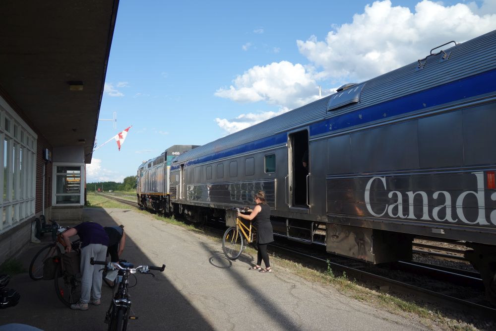
A number of cyclists took this train to Chambord, a great launching point for the Véloroute des Bleuets
While the train was scheduled to leave Montreal at 8:15, the VIA Rail Canada agents I spoke with on the phone prior to the trip told me to get there at least an hour early because my bike would need to be loaded into the baggage car, and could potentially need to be put in a box if the train was carrying a lot of freight. Not wanting to mess around, I got up early and rode my bike to Montreal’s central train station to check in. There were about 7 other cyclists who showed up the same time as me, which was encouraging. All of us were told to remove the paniers and other bags from our bikes, which we had to carry onto the train to our seat. Then we handed the bikes to the agent at the baggage desk and – fingers crossed – our bikes would be on the train.
This whole process took about 20 minutes, so I still had 40 minutes left to get breakfast. You will want to do this before you get on the train. You will also want to go to a store (perhaps the day before) and buy yourself lunch. The food on the train looked pretty awful. Plus, when the train pulled into Chambord that afternoon at 4:30, I wanted to be ready to ride. I didn’t want to have to stop first and eat.
When the train departs, you realize that this will be an unhurried affair. First, they made us line up the train gate when the departure announcement was made. Then we all stood there for at least 20 minutes, holding our bags for apparently no reason. Finally, they sent us down to the train, which was actually two trains linked together. Each train had an engine, a luggage car and a passenger coach. I found out that about halfway through the ride, they would separate the train, sending the other half to the remote town of Senneterre, while my half would go to Jonquière.
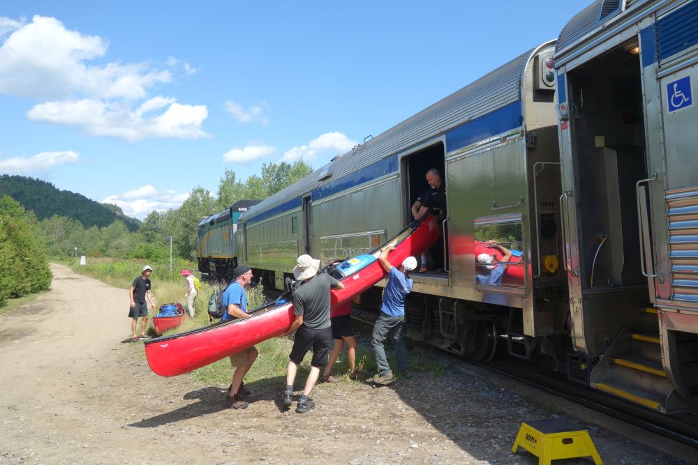
The train takes you through some very remote areas, where you make some unusual stops. A canoeing group got on at a whistle stop next to a raging river.
The train conductor and staff were super friendly, which was good, since you would see these people all day. The conductor made his way up and down the car chatting with everyone, getting to know us as we settled in for the long trip. The train ride was fantastic, but long. After passing through suburban Montreal and surrounding farmland, we were soon in the wilderness, making stops at teeny-tiny stations. Some places were logging towns. Others were remote wilderness resorts with few roads, where the train was the primary access. To my surprise, people were constantly getting on and off of the train at these little whistle stops, with all kinds of baggage, including canoes and cases of beer, all of which were loaded into the baggage car with the bikes.
Finally, the train made it to the other side of the wilderness and Chambord was the first stop, right near the lake. Most of the other cyclists got off here, and we all reassembled our bikes right at the station. Right in the parking lot was a directional sign for the Véloroute des Bleuets. So I just followed the signs, and I was on my way.
A couple of blocks away from the train station is the bike path. You have arrived!
When I got on the bike, I had no idea what to expect or what I would see. So I was amazed at how clearly the Véloroute was marked. Rolling through Chambord, there were signs and lane markings everywhere. And as I left town, I soon found myself on a beautiful bike path in between the road and Lac Saint-Jean. I had no idea it was going to be this nice!
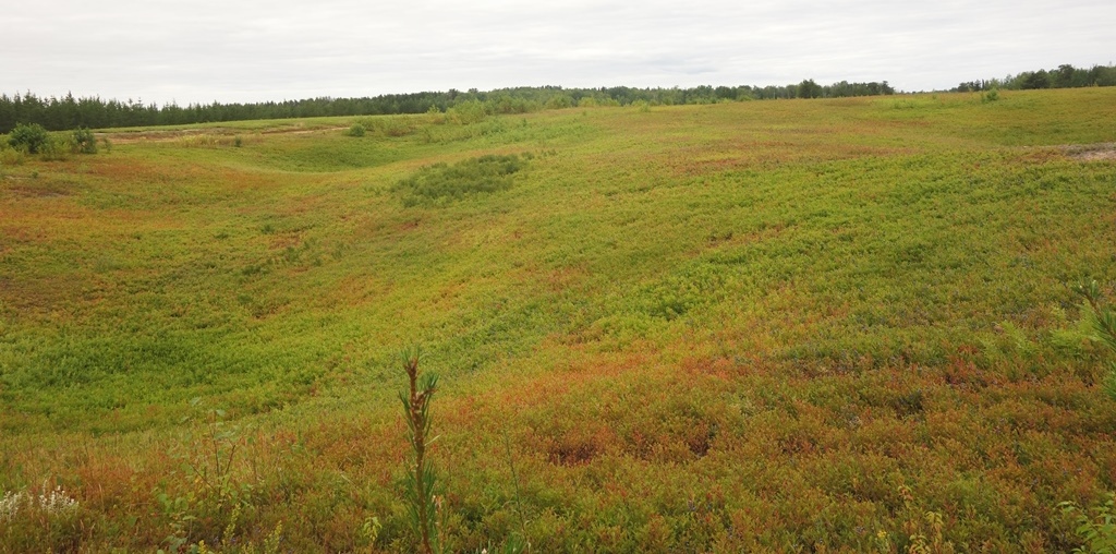
With only a few hours of daylight, after consulting the comprehensive guide of the route, I decided I would ride to Val-Jalbert, which was described as a “ghost town” historic site that also has camping and a restaurant. The detailed maps in the printed route guide made it very easy to plan my afternoon (and the subsequent days). The route around the lake has mileposts noting kilometers running clockwise (Chambord is at KM 102). The route is also color coded, with green meaning bike paths and yellow meaning on-road riding. Val-Jalbert was only 9 KM away, so I could do a small warm-up ride, lay out my tent, have a nice dinner and check out some local history.
However, once I arrived at Val-Jalbert,I realized there were a couple of key details the guide left out. While the campground was beautiful with a pool and great facilities, Val-Jalbert turned out to be more of a super-commerciallized, touristy outdoor museum than a ghost town. Their restaurant turned out to be this involved affair that required reservations, often paired with a room booking. Anything related to the historic site was locked behind gates (which closed at 6), requiring you to pay a $30 admission. This was clearly something that you would go to and spend an entire day (and night) at and it’s completely useless for people just passing through at the end of the day. It would have been nice to know this beforehand, since I could have potentially planned more time to visit it. And of course, now I had no place to eat dinner. Thankfully I overindulged on paté on the train and I wasn’t super hungry. So I bought 2 pre-packaged egg salad sandwiches out of the campground store, went to the pool, saw a rainbow, and called it a night. Still not so bad, I guess.
The only part of the Val-Jalbert “ghost town” you can see for free. But it’s a lovely hike from the campground.
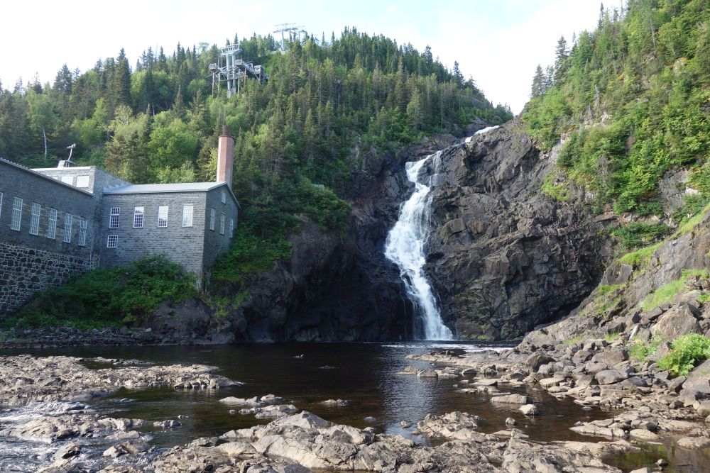
The next morning, I availed myself of the campground’s hiking trail and I hiked up the Ouiatchouan River, on the opposite bank from the historic park. A massive waterfall awaited me at the end. At least I got to see something! After eating an energy bar (for lack of other options) I rode 7 KM on a glorious bike path to Roberval, the next big town along the lake. This town had a wide range of services, so getting a late breakfast was easy. At that point, given the nice weather, I decided to try to make it to Albanel, 67 KM away. Albanel had a municipal campground and a restaurant. It was also at the junction of a secondary bike route, called Au Fil des Rivières, which was a loop promising waterfalls and blueberry fields. If I stayed in Albanel, depending on how I was feeling, I could ride this loop in the evening, or early the next day.
Fuel for the road!
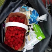
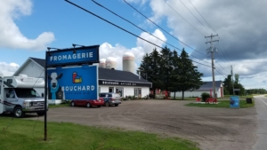
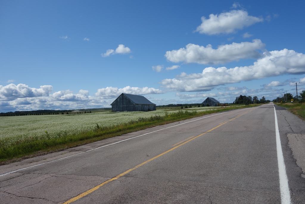
Once I started riding, I took my time, taking in sweeping views of both farms and lake. As the guidebook promised, I passed by a farm that was in the middle of harvesting raspberries. I got a huge basket for only $6. They must have been picked that day, they were so fresh! Further on down the road, the guidebook alerted me to an organic, artisanal fromagerie, Bouchard Artisian Bio – a farm owned by the same family for five generations. After tasting all of the amazing cheddar, I bought a brick of it along with a bag curds. All I needed was some bread from a store and this would be lunch and snacks all day.
One of many fromageries you will pass.
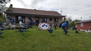
By late afternoon, I had reached Albanel. Since it was my first full day (and the campground had a pool!) I decided to save the Au Fil des Rivières side loop for the next day and instead enjoy the sunset with a beer after unwinding in the pool. In Albanel, very few people spoke English, so I had to rely on my high-school French from decades ago. So after arranging for my campsite in my horrible French, I headed over to the local blueberry museum, which is a must-see if you are ever in Albanel. They sell slushies made with local blueberries, which are unbelievably refreshing after a day of riding.
One of several blueberry exhibits you will pass.
Albanel only had one restaurant, a casse-croûte (a type of restaurant featuring poutines, hamburgers, etc.) that also had pizza. So the dining choices were limited. Fortunately, the town also had a supermarket, so I was able to buy food for the next day as well. At this point, I was finding it advantageous to keep stocking my panniers with fresh, yet durable, foods that I could snack on all day, and that could also serve as a meal if I needed it to. So this meant buying a lot of breads, local cheeses, cheese curds and fruit. And speaking of fruit…sometimes I could just pick it myself.
I got an early start and resolved to do the the 44 km Au Fil des Rivières side loop before pressing on along the rest of the Véloroute des Bleuets. Being a loop, I left my camping gear and a pannier at my campsite while I did the ride to make my bike lighter. I cruised down a road that was long and straight, yet it rolled up and down with a topography that changed. I reached the super small town of Girardville where there was a general store that sold pastries baked on the premises. I could see the huge baking room behind the register. I bought a huge raspberry pastry packed in a styrofoam tray wrapped in shrink wrap. I bought coffee out of a machine and I had a great mid-ride breakfast. I stashed the remaining 80% of the pastry in a pannier and took off for the ride back to Albanel, on an off-road path that went through endless blueberry fields and along a series of waterfalls. It was here that I stopped several times for snacks of blueberries that I simply picked myself.
You can see (and taste) endless blueberry fields along the Au Fil des Rivières bike path.
Back in Albanel it was time to get serious about the day’s ride. Because I had reserved a waterfront campsite at Pointe-Taillon National Park I needed to ride 55 km to Péribonka to catch a ferry to the park. The last ferry was at 6 p.m. and, if I missed it, it would add 30 more km of riding for the day. Since I had already ridden 44 km, I was motivated!
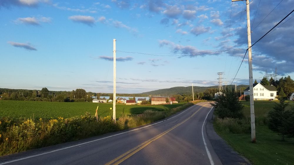
Having studied the maps in the guide, and checking what was ahead in each town by using Google Maps, I was able to determine that I could get everything I needed in Péribonka for dinner and a camping breakfast. So I got on my way, riding through more beautiful landscapes, on a combination of clearly signed, bike paths and on-street bike routes. However, I began to notice that in some of the larger towns, the wayfinding breaks down due to missing (or confusing) signs or pavement markings that have eroded away. As a result, I occasionally found myself riding on high-traffic roads that were stressful to ride since I had strayed from the route. It was frustrating since on my 6-day trip, this kind of situation happened about once per day.
When the Véloroute shares a roadway, this is what it typically looks like.
I trucked on to Péribonka fearful that if I was on the last ferry of the day, it could be full, since the guidebook stated it only had room for 12 bikes. I had seen a lot of cyclists riding that day, so who knows how many more people are taking this ferry? Péribonka had a nice restaurant facing the lake. When I arrived there, I checked with the ferry operator to see what my options were. The 5 p.m. ferry was waiting….with nobody on it. The 6 p.m. was likely to be just as empty. So I had an hour to eat dinner and shop for supplies at the only store in town, a convenience store near the ferry dock.
At 6, I was the lone passenger on the ferry. So I chatted with the captain as he brought me across. I was now in Pointe-Taillon National Park, which is not really a national park. (Quebec calls its provincial parks “national parks”). But it didn’t matter – the place was amazing! I continued along a bike path that went through forests, wetlands and dunes. I scanned the horizon for wildlife until the path went next to the lake with a series of beautiful sand beaches along it. I found one overlooked by a bench, with a safe accessway down to the water. So I stopped, changed into a suit and went for a swim as the sun began to sink in the sky. It was so refreshing after more than 100 km of riding!
Back on the bike, I rode the final few km to my campsite. The site was wooded, but with a view of the lake and easy lake access. After setting up my tent, I went for another swim as the sun set. I watched a huge orange moon rise over the lake, and then I went to bed.
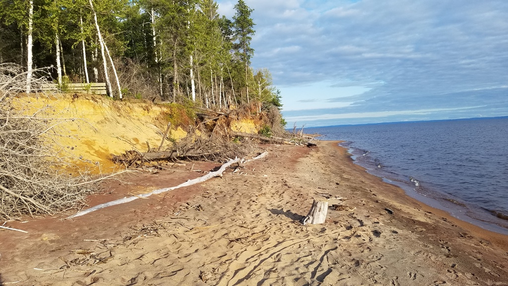
This quiet beach at Pointe-Taillon National Park offered the opportunity for a refreshing swim near the end of the day’s ride.
The next morning, I took down my tent, left my bags at the site and rode around the park’s bike paths to see more of the natural areas. I was not disappointed by a wildlife sighting of two large birds running across the path. It was worth the extra riding to see. I also checked out some of the other campsites in the park. Some of them were right on the sand by the water. Others were larger, for bigger groups. But all were the same in the sense that you could only bike or hike to all of these sites. No cars allowed!
On my final day around Lac Saint-Jean, I would need to ride at least 86 km to Métabetchouan-Lac-à-la-Croix. That was a sizable town that had restaurants and motels. If I wanted to go further, I could press on 18 km more to Hébertville where I could camp. I would decide when I got there.
The ride that day was busy, since I passed through the City of Alma, the largest municipality along the lake, positioned on an island between the Grande-Décharge River and the Petite-Décharge River. It was here that I began to see (and ride across) a number of hydroelectric dams that were associated with the rivers, both of which confluenced into the Saguenay River, the main river of the region which flowed between Lac Saint-Jean and the Saint Lawrence River.
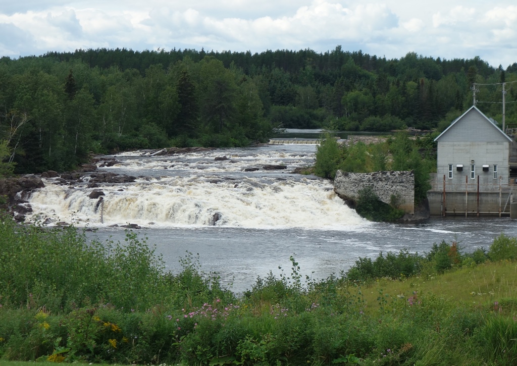
Riding around Lac Saint-Jean you cross many streams and rivers, often with waterfalls and rapids. Some falls have the remnants of mills that once harnessed the water power.
I was able to skip the main part of the City (and shave off a few miles) by taking another delightful bike ferry across the river. Once again I was the only passenger. After Alma, it was back riding along the picturesque lake all the way to Métabetchouan-Lac-à-la-Croix where I needed to decide my final plans for the day. But good fortune allowed me to consider this decision on a sandy beach with changing rooms, a restaurant and live music. I changed, took a relaxing swim, and listened to the music while I contemplated that I had enough daylight to push on to Hébertville. I would leave the shores of Lac Saint-Jean at this point and head west along the Horst de Kénogami bike route. This would be a 72 km long, mostly on-road bike route that would no longer be flat. Instead I would go over some more serious hills on my way to the regional capital of Saguenay where I would experience the Fjord du Saguenay. I’ll tell you all about this in the fourth and final installment of this series.
At the end of the day, I rode my last 18 km on the Horst de Kénogami bike route to Hébertville. I camped right along the lake in the distance.
Ocean Parkway Coastal Greenway (Jones Beach Bike Path)
/in Bike Paths, Long Island /by Laura WillisIf you do the entire 20-mile ride, you will actually be riding on a series of bike paths with different names that go along the highways that Robert Moses constructed to provide access to Jones Beach State Park as well as Captree State Park and Robert Moses State Park. The western portion of this trail system is the Ellen Ferrant Memorial Bicycle Path which runs in a north-south direction along the Wantagh State Parkway between Cedar Creek County Park and Jones Beach State Park for about 5 miles. Once you arrive at Jones Beach, the trail turns east and you are riding on an older section of the Ocean Parkway Coastal Greenway which goes between Jones Beach State Park and Tobay Beach, which is Town beach run by the Town of Oyster Bay. East of Tobay Beach is the newest segment of the trail, which is about 10 miles long and passes through Gilgo Beach before reaching Captree State Park where the trail ends.
Captree State Park is a beautiful spot. You can enjoy a view of the Robert Moses Causeway from a picnic area, but you cannot ride a bike over it. The bike path ends (or starts) here with no bikeable connections to other roadways.
Planning your ride
While the entire bike path system is about 20 miles, any ride you do on this trailway will need to be “out-and-back” unless you have someone picking you up at one of the parking areas along the trail. So to ride the whole path, you will actually need to ride 40 miles if you are parking at one of the trail’s endpoints at either Cedar Creek County Park or Captree State Park because it’s one-way out and one-way back. There is no way to do this trail as a loop. While the Ellen Ferrant Memorial Bicycle Path will get you across the bay on the west end of the path, you would need to ride your bike on the Robert Moses Causeway on the east end of the path to close the loop, and bikes are not allowed on that road. So unfortunately, when the bike path reaches Captree State Park, the trail is a “dead-end” and you have to go back. Or you could make Captree State Park your starting point and ride west before turning around.
The Ellen Ferrant Memorial Bikeway crosses the bay on a series of bridges with beautiful views.
If you want to take public transit to the Jones Beach bike path you can do that too. The Wantagh station for Long Island Railroad is a short distance away from Cedar Creek County Park and its easy to hop on the bike path from there. However, whatever distance you ride in the eastern direction, you’ll need to turn around to get back.
If you are driving to the bike path in a car, you have several choices of where to park, based on how much you want to ride. The only place where you can park for free is Cedar Creek County Park. If you park at either Jones Beach State Park or Captree State Park, you will need to pay the parking fees associated with those State parks, which is usually around $8-10 unless you have an Empire Pass. It is also possible to park in the middle of Jones Beach Island at either Tobay Beach, Gilgo Beach or Cedar Beach. However, these beaches are Town-controlled and have higher parking fees (unless you are a Town resident). For example, parking at Gilgo Beach costs $40 on a Friday, Saturday, Sunday or holiday and $20 on all other days. Residents of the Town of Babylon can park for free. You can also park for free if you arrive later in the day after the payment booth is closed. Parking is also free off-season, but check with the Town before you go to make sure they are not charging.
Go for a swim at one of the many public beaches you will pass. Each beach has bike parking, restroom access and a food concession.
Experiencing the trail
No matter where you ride along the Jones Beach bike path, it is a great experience. You are right along the water for the entire time with great views of the bay between Jones Beach Island and the main part of Long Island. As we mentioned earlier, the trail goes through a number of areas with services and beach access, and helpful signage along the trail informs you about what services are available in which places. There are restrooms and places to eat at Jones Beach, Tobay Beach, Gilgo Beach and Cedar Beach. You can also lock up your bike at any of these locations and go for a swim on the ocean side of the island by using underpasses that go underneath Ocean Parkway. If you are arriving by bicycle you won’t have to pay the beach access fees.
We saw scores of baby bunnies along the trail. But be warned….when we stopped to take this picture, we were almost eaten alive by biting flies!
Wildlife also abounds along the pathway. On the day we were riding there, we saw scores of rabbits along the trail popping in and out of the brush. Unfortunately insects are also a major force in this area as well, so depending on the day, you will want to have bug spray available. For example, just stopping to take a picture of a bunny can invite a swarm of biting flies that will leave welt-like bikes all over any exposed skin. So in these areas you will need to keep moving so that the flies cannot land on you. Or bring bug spray.
Wind is also a major consideration to think about when doing this ride. Since Jones Beach Island is a barrier island, it can receive a lot of wind. So depending on the day, and the fact that the trail requires you to ride “out-and-back”, you will likely have the wind at your back in one direction….and the wind in your face in the other. So definitely think this through before you start riding!
Captree State Park is a great ending for this bike path. You can walk along the shore and see the Fire Island Lighthouse off in the distance.
Also keep in mind that while there are services are available at the different beaches along the route, there is nothing in between those hubs along the bike path but open road. So make sure you know the distances between the various amenities before you set out on your ride.
Riding the Empire State Trail: NYC to Canada
/in Bike Paths, Hudson Valley, NYC, Rail Trails /by Laura WillisRiding the Maybrook Trailway
/in Bike Paths, Hudson Valley, Rail Trails /by Laura WillisThe Maybrook Trailway is the newest rail trail in the lower Hudson Valley and it is also the very eagerly-awaited “missing link” of trail between the former Putnam Division Railroad trailway system (also known as the Putnam Trailway, North County Trailway, South County Trailway and Putnam Greenway depending on where you are) and the trail system centered around the Walkway-Over-the-Hudson (which is comprised of the walkway itself, the Dutchess Rail Trail, the Hudson Valley Rail Trail and the Wallkill Valley Rail Trail). With the construction of the Maybrook Trail, it is now possible to ride continuously on a bike path (with no cars) between New York City and Kingston – almost 100 miles! All of this is part of the new Empire State Trail which goes across the entire state (although not all of the Empire State Trail is bike paths).
The Maybrook Trailway travels between Brewster and Hopewell Junction for 24 miles. There are no services available or restrooms.
The Maybrook Trailway has been a long time coming. Instead of being a “rail trail’ the Maybrook is actually a “rail with trail” traveling alongside the Maybrook Line owned by Metro-North Railroad. The trailway itself is also owned by Metro-North, which makes it one of the only bike paths to our knowledge to be owned and operated by a commuter railroad. The uniqueness of this arrangement also makes for a very unique trail experience, as you travel through very remote areas that are only accessible by this rail line. Far from development and traffic, the Maybrook Trail offers a quiet experience with the sounds of birds and wildlife as a soothing soundtrack in the background. In fact, the Maybrook Trailway is probably one of the most scenic bike paths in our entire region.
Wide open and quiet, with only the sounds of nature surrounding you.
The Maybrook was a mountain railroad, crossing the Appalachian Trail.
However, this sense of solace comes at the expense of convenient services. There are no easily accessible services anywhere along the trail and there are no restrooms along its entire 24 mile length. So you need to go into this ride prepared, or you could consider one of our tour packages where we provide rest stops and services to our riders. There are also no places to sit along this trail except for the stone boulders placed near road crossings. This is a shame since there are so many pretty views that would be nice to sit and enjoy.
As you would expect from a transit agency, the Maybrook Trailway has lots of clear signage. Most of this involves telling you what you can’t do: don’t go on the tracks, stay off of private property, don’t swim in this lake, etc. But there are also lots of great informational panels telling
Although there are no services or restrooms along the Maybrook Trail, when you reach the end in Hopewell Junction, there are restrooms and vending machines.
you about railroad history and the many settlements that you pass. Also, because the Maybrook Trailway goes along train tracks that connect to the Brewster rail yards, you can easily take Metro-North railroad from NYC with your bike to get to the trail. It’s also possible to ride the 44 miles to Poughkeepsie (via the Dutchess Rail Trail) and then take the train back to the city via the Hudson Line while you watch the sun set over the Hudson River. Discount rail fare is available for this excursion with our tour package.
New York Metro Area Bike Paths That Are Great for Cross Country Skiing
/in Bike Hacks, Bike Paths, Hudson Valley, Rail Trails /by Laura WillisIn most cases, to ski any of these trails you will need to have your own cross country skis. While this may seem like a major purchase, XC skis cost much less than downhill skis and they will last you many years. Major retailers that sell them include REI and L.L. Bean. There are also a few local retailers who sell them, including Pawling Cycle & Sport and Rock & Snow, both in the mid-Hudson Valley. Rock & Snow also offers rentals if you aren’t ready to buy yet.
Fahnestock Winter Park
Fahnestock Winter Park is perhaps the best choice for New Yorkers who are looking to try cross country skiing for the first time, or if you don’t have equipment. Every winter, the beach area, campground, and hiking trails in Fahnstock State Park are transformed into a nordic skiing center whenever we get a big snowfall. Groomed trails range from easy to difficult and they have rental skis and lessons available. This is the closest nordic skiing center to NYC, so it can get a little crowded. But it is also super easy to get to since it is right off the Taconic State Parkway. You can also get here by public transit by taking the Metro-North Railroad to Cold Spring and then cabbing it over.
Bronx River Pathway
If you are looking to just get out for a short ski trip, you can’t beat the Bronx River Pathway in Westchester County for convenience. This bike path parallels the Metro-North Harlem Line and the Bronx River Parkway so it’s easy to get to by car or train. Plus it offers the advantage of a one-way trip where you can use the train to get to a starting point and then ski back. The scenery is super nice as you pass through dense woods. The nicest segment for skiing is between Hartsdale and White Plains since it has a fair amount of up-and-down and there are no road crossings. If you are looking for a flatter section, try the area between Bronxville and Scarsdale.
The section of the greenway just south of White Plains is great for cross-country skiing when it snows.
Old Croton Aqueduct
With the leaves off the trees, you get a near constant view of the Hudson River and the Palisades from the Old Croton Aqueduct bike trail through Westchester’s river towns. This trail is consistently flat and, since it parallels the Metro-North Hudson Line, it is also very easy to get to by train or do a one-way ski. You also pass through many town centers, which make it easy to stop for lunch.
Rockefeller State Park Preserve
Another regional hot spot for cross country skiers is Rockefeller Preserve in between Pleasantville and Tarrytown in Westchester. This park features a large network of carriage trails that are primarily used by hikers and horseback riders. But after a snowfall it becomes a prime local destination for cross country skiers who ply its ungroomed trails. Probably one of the most scenic parks in our region, this is a great place to check out. You could also get here by train to Tarrytown or Pleasantville in combination with a cab ride.
Ward Pound Ridge
Similar to Rockefeller Preserve, but further north, is Ward Pound Ridge Reservation, which also has a large network of carriage trails that are perfect for cross country skiing. The park isn’t far from the Katonah Metro-North Station, which also has taxi service.
Westchester County Golf Courses
If skiing across open landscapes instead of wooded trails is more appealing to you, all six of Westchester County’s golf courses are open to XC skiing and sledding. These golf courses offer a mix of terrain from steep hills to flat fairways, so there is something for every ability. Plus the parking lots are always plowed and you can even take Bee-Line buses to the Dunwoodie and Saxon Woods Golf Courses. (For Saxon Woods, your best bet is to take the bus to the pool parking area where you can access the parks hiking trails which are also good for skiing).
High Point Cross Country Ski Center
Finally, if you are looking for another large nordic center, but you are willing to travel a little further, High Point Cross Country Ski Center in New Jersey is another place where ski rentals (and even snowmaking and night skiing!) is available.
Resources to find out more
If you want more guidance in figuring out where to go or where the best conditions are, there are a couple of great resources for cross country skiers in our area. Check out Ski the Northeast which is a comprehensive website for skiers from the New York Metro area. Another great resource, particularly if you are interested in updates about ski conditions and other general information, is this fantastic email forum from the New York/North Jersey Chapter of the Appalachian Mountain Club. It’s a great group to learn more about skiing and ask questions.
Riding the Old Croton Aqueduct Trail
/in Bike Paths, Hudson Valley, NYC /by Laura WillisThe growth of New York City into the place we all know today has always been linked to the ability to bring fresh water to an urban environment surrounded by salt water estuaries. In the early 19th century, this was a major problem as the city began to push north from its original settlement at the southern tip of Manhattan. At that time water was obtained from wells, many of which were contaminated. This lack of clean water was responsible for both yellow fever and cholera epidemics. Water was also needed for fire suppression. By 1833 it was time for the City to begin work on a new fresh water supply. Nine years later the project would be complete, connecting the Croton Reservoir to the growing city. Today, although the aqueduct is no longer in use, most of its infrastructure is still there. Much of the aqueduct is now a State park (or NYC Park), and the land above it is a fascinating trailway that you can ride your bike on with great views of the Hudson River. The Old Croton Aqueduct Trail (OCA) goes across the Highbridge – one of the nicest car-free bridges in our region. The OCA is also a great way to get to the new Mario M. Cuomo Bridge Bike Path.
The OCA trail is unpaved for most of its length. This is one of the wider (and smoother) parts. You should ride this with a hybrid or mountain bike.
While the initial aqueduct was 41 miles long going between the Croton Reservoir in Westchester County and the Croton Distributing Reservoir (now the site of the New York Public Library on 5th Avenue and 42nd Street) the 26-mile portion in Westchester County is the part we will be discussing below. This is the most contiguous part of the trail that offers the best riding. While portions of the OCA trail in New York City are spectacular (like the Highbridge) the route isn’t contiguous or clear.
No matter which portion of the OCA Trail you want to ride, we highly recommend purchasing a map from the Friends of the Old Croton Aqueduct for $5. This map will show you the exact route, which can be confusing and hard to follow for the uninitiated. But once you’ve ridden it, you’ll see why it was worth the effort.
The OCA trail can be narrow at times and you will have to follow small signs to stay on the route. We definitely recommend buying a map for $5.
The Westchester portion of the OCA Trail is almost entirely unpaved. You will need to watch out for bumps, roots, rocks, mud and debris. Some portions are wider than others, and the route is almost entirely shaded. Peek through the trees and you’ll see great views of the Hudson River and the Palisades throughout most of your ride. You’ll also see many, many remnants of the aqueduct, like ventilation towers, weirs and more. But make no mistake, the trail can be rough. So do not attempt this trail with a road bike. Hybrid or mountain bikes are a must!
One of the many views you’ll get of the Hudson River or the Palisades while riding the OCA trail.
There are numerous access points to the OCA Trail from its many street crossings. The OCA once flowed through every riverfront village or town in Westchester between Yonkers and Croton-on-Hudson. This means that the trail offers direct access to downtown areas in Hastings-on-Hudson, Dobbs Ferry, Irvington, Tarrytown, Sleepy Hollow and Ossining and it is also very close to downtown Yonkers and downtown Croton-on-Hudson. All of these areas have Metro-North train stations, so you can easily do a ride that starts in one place and ends at another. And that also makes this trail easy to get to from the city.
The OCA Trail goes directly through a number of downtown areas. So you are never far from services or train stations.
If you want to start your ride at the south end, a good place to start is at Glenwood Avenue, particularly if you are taking the train. This trail access point is very close to the Glenwood train station, but beware, you will have to go up a big hill to get to the trail.
Heading north the trail is continuous, but you will need to pay attention to your map or to signs (where available) to get you through tricky spots where the route gets confusing. In most downtown places the trail is shared with roadways or parking lots. Try your best to follow along. In some cases, it may even feel as if you are riding through somebody’s front or back yard. It’s OK – you are still on the trail.
Hey, am I riding through someones yard? Yes you are…but it’s also the trail!
As you approach Tarrytown you will pass by some beautiful properties including Lyndhurst Castle. These were once Hudson River estates for the wealthy. Lyndhurst, in particular, offers tours. However, once you pass Lyndhurst, you will get to your first major interruption in the trail, since it is here that the aqueduct was obliterated by the construction of I-287 and the Tappan Zee Bridge. So you will have to ride along Route 9 for a while until you get to downtown Tarrytown where the OCA trail picks up again. This is a busy road, so it isn’t the greatest for cycling. But you could always ride on the sidewalk if you did not feel safe. It is here that you will also pass the entrance for the Mario M. Cuomo Bridge bike path.
The OCA trail goes past many remnants of the aqueducts infrastructure, such as this weir building.
If you want to ride north of Tarrytown, the OCA trail offers some nice interrupted stretches. But there are also major gaps in the trail that you will need to get around. Once again, having a map will really help you figure this out. The biggest obstacles are Sleepy Hollow High School (which was built right over the aqueduct), a missing piece of trail in Scarborough, and passing through downtown Ossining, where you will need to use local streets (and stairs) to follow along the path. The last major interruption in the trail is where Route 9A was constructed across the aqueduct (another highway obliteration…). Here you will need to skirt around the fence of a training and conference center owned by GE, so again you will need to pay attention to signs (and your map). But the last couple of miles are spectacular, as you move away from the Hudson River into the Croton River gorge. The trail ends at the Croton Dam, which is a site to behold. You can bike across the top of the dam, or go down to the gorge below, which is a County park. If you are taking the train back, just reverse your course back a few miles and you can access the Croton-Harmon Metro-North station relatively easily.
Riding the Esposito Trail (and the Old Erie Path)
/in Hudson Valley, Rail Trails /by Laura WillisA view of the Mario Cuomo Bridge from the Esposito Trail.
If you are planning to ride across the new Tappan Zee Bridge (or Mario M. Cuomo Bridge) bike path, you are probably wondering “what other trails connect to this bike path”? Well, look no further than the Raymond G. Esposito Memorial Trail. The Esposito Trail is a great way to connect from the bridge to the Villages of Nyack, South Nyack and Piermont. This trail will also connect you to the Joseph B. Clarke Rail Trail in Sparkill via its extension called the Old Erie Path
Clear signage takes you from the Tappan Zee Bridge bike path to the Esposito Trail.
The new Tappan Zee Bridge bike path is a great new amenity for cyclists in the Hudson Valley. The Esposito trail connects almost seamlessly with the bridge bike path to take you directly to South Nyack and Nyack where there are plenty of stores, restaurants, and services. These bike-friendly villages are a great place to head to after riding over the Mario M. Cuomo Bridge.
The Esposito Trail is wide and easy to ride in between the bridge and Nyack.
You can also head south on the Esposito Trail, which eventually becomes the Old Erie Path. This trail follows the alignment of the former Northern Railroad of New Jersey, which once ran passenger trains between Jersey City and Nyack. Passenger service ended in 1966, and today it’s another great rail trail for cyclists. The surface is a combination of dirt and gravel, so make sure you ride this with either a hybrid bike or a mountain bike. Sturdier road bikes should also do okay.
Watch out for narrow sections like this one. One way only!
While the trail is generally wide and smooth north of the bridge, as you move south, it gets bumpier and narrow. There are a couple of spots where the trail becomes very narrow and it’s one-way at time, so be aware of people coming in the opposite direction!
Check out the beautifully restored Piermont Station.
When you reach Piermont you will see a beautifully restored station. Keep riding south and you will eventually get to the hamlet of Sparkill where you can easily pick up NYS Bike Route 9 which takes you to the George Washington Bridge. Sparkill once had a major junction of railroads in its center….which is now a major junction of bike paths. From here, you can get on the Joseph B. Clarke Rail Trail and ride further. Or you can stop and get lunch here at one of several restaurants. With the connection to Bike Route 9, the Esposito Trail can be a great part of a circular route that features the Old Croton Aqueduct, the Mario M. Cuomo Bridge and Bike Route 9 back to Manhattan via the George Washington Bridge.
Riding the Mario M. Cuomo (Tappan Zee) Bridge Bike Path
/in Bike Paths, Hudson Valley /by Laura WillisThe replacement of the old Tappan Zee Bridge with the new Mario M. Cuomo Bridge has been a long time coming. Everyone hated that old bridge…especially cyclists and pedestrians, because that bridge had never been built with them in mind. How could such a critical link in the Hudson Valley not include bicycles and pedestrians? Finally, the bridge was torn down and replaced. And the last phase of that replacement is now open: the Governor Mario M. Cuomo Bridge Path! (Or to some, the new Tappan Zee bike path).
While it’s annoying that the bike path was the last phase of the bridge to open, everyone is glad it is finally here. This past weekend was its first weekend of operation, and it was packed with visitors! Here’s what you can expect if you ride the new Tappan Zee bike path.
Manage your expectations
If you had the ability to design a brand-new, state of the art, bike path from scratch on a brand new bridge, you’d do something amazing, right? Well that’s not what the Tappan Zee bike path is. It is more or less just a 12-foot car lane repurposed into a multi-use path with a white stripe going down the middle. Pedestrians on one side, bikes on the other. Cross the line at your peril! If you’ve been on a bike path on almost any other local bridge, this is more or less the same deal. You’ve got cyclists of all abilities, all competing for the same space…right next to pedestrians. It is absolutely essential to keep your wits about you. But it’s a great path if you take your time and go slow. But at the same time, it’s also a really good idea to ride this path with a mirror so you can be ready for the packs of lycra-clad riders who come blowing through in a paceline, perilously close to young mothers riding with toddlers on the backs of their bikes.
You told me there would be river views! Not here, as opaque panels shield your eyes from something you are not meant to see.
Besides, why not take your time and enjoy the view? It’s fantastic! But if you start out on the Westchester side, you’ll need to wait a bit. For some reason, they put opaque panels blocking your view for the first part of the ride. But then things open up, and there are 6 little rest areas you can stop at to enjoy the view. These rest stops have whimsical names like “Fish and Ships”, but they are mostly just bland seating areas adorned with touchscreen monitors that will inform you about a different Hudson River topic.
It’s time for some “fish and ships” at one of the seating areas along the bridge. Always a nice view. There’s also a touch screen for you to look at and touch.
The seating areas also offer some artistic flair for the bridge along with other public art installations that you can look at. The art is a great distraction from the sounds of 18-wheelers and buses roaring past you. Don’t forget, this bridge carries the NYS Thruway. But at least in the seating areas, the mesh suicide-proof fence between you and the traffic is replaced by glass paneling to attenuate the vehicular noise while you browse those touchscreen panels.
Get lost in public art installations along the bike path.
The Rockland side of the bridge approaches the shore at a much lower elevation than the Westchester side, and dispenses you amidst the tangle of Interchange 10. The space here is tight and narrow-feeling thanks to the concrete sound-barrier walls. But at least you will be in the shade on a hot summer day.
Approaching the Rockland side is “easy-squeezy” as the crowd is shunted between sound barrier walls and the suicide fence next to the traffic.
The bike path has great amenities on both landings of the bridge. Each landing has a clean restroom near the parking lot, although there are few places to lock up your bike while you go inside. Each landing also has at least one food truck and a small area to consume the items you purchase.
Grab a bite from a food truck and eat it on a metal picnic table with absolutely no shade. Public art provides a visual contrast to the pavement that surrounds you.
Getting there
The Mario M. Cuomo Bridge is unique, compared to other bridges with bike paths, in that it has free parking for people to drive to the bridge and then ride or walk across it. But the bridge is also connected to other bike paths on both sides of the river, so you can also ride your bike to it. On the Westchester side, the bridge is very close to the Old Croton Aqueduct Trail and the Westchester RiverWalk trail. It is easy to ride from these trails to the bridge by riding on the sidewalk of Route 9 between the trail and the bridge. You can also ride in the road if you want to.
This severe-looking design was clearly invented by the highway engineers. Welcome to the parking area.
On the Rockland side, the bridge connects directly to the Esposito Trail, which in turn will take you directly to downtown Nyack. Nyack is probably the easiest community to visit when you are riding the bridge’s bike path. On the Westchester side, you can also visit Tarrytown, but you’ll have to ride down busy Route 9 to get there. You could also go the other way and ride to Irvington, using the Old Croton Aqueduct or RiverWalk trails.
The bridge’s bike path connects to other trails. Clear signage ensures you will not get lost.
Another way to get to the bridge’s bike path is to use the Hudson Link bus. These buses ply the I-287 corridor and offer stops near the bike path during certain times of the day. The buses all have bike racks that hold up to 3 bikes. So you can ride or walk the bridge one way, then take the bus back.
Hey! Don’t forget that the current governor named the bridge after his father, a previous governor. These signs ensure you don’t forget.
Riding the O&W Rail Trail
/in Bike Paths, Hudson Valley, Rail Trails /by Laura WillisThe City of Kingston sits right next to the Catskill Mountains along the Hudson River. But it also sits at the end of two river valleys that run south to north. These two waterways: the Roundout Creek and the Wallkill River, have their confluence just south of Kingston. From that point north, the Roundout Creek becomes a navigable waterway which leads to the small harbor that made Kingston a hub of industrial activity in the Mid-Hudson Valley.
The Roundout Valley has long been a transportation corridor. First it was the Delaware and Hudson Canal that once transported coal between northeast Pennsylvania and the Hudson River. Later the canal was replaced by the New York, Ontario and Western Railway (the O&W). And now that railroad alignment is another great bike path for you to explore. Riding this trail can be a great component of any of our Hudson Valley bike tours. You could also combine it with our Catskill Scenic Trail tour and make a weekend out of it.
The O&W is a quiet, peaceful ride. But it is still a work in progress in many ways. There are a number of gaps in the trail, and some parts of the ride are kind of rough. So you will definitely want to ride a hybrid bike or a mountain bike if you want to experience any of the rough parts. There is a good map showing the different segments (and gaps) on the trail’s official website. The map also shows a number of parking areas as well. You can also take public transit to parts of the O&W trail by using Route EU of the Ulster County Area Transit bus system. These buses are equipped with bike racks and can help you ride this route one-way, and take the bus back to your start point.
Perhaps the roughest section of the trail is in Kingston where the O&W met the other lines that made Kingson a regional rail hub. The trail begins in the parking lot of the Super 8 hotel where the O&W once joined the tracks that are still in use by the Catskill Mountain Railroad. Riding the trail in this area is basically riding on bumpy grass, and it can be tough at times. If you want to skip this area, you can start instead at the parking lot just off of Route 209 in Hurley. From here south, the trail conditions begin to get better and it is a nice quiet ride through beautiful woods with great scenery. Although there are a couple of rough spots on the trail here and there. Once you reach High Falls, you will begin to ride along the Roundout Creek where you can see remnants of both the D&H Canal as well as the O&W Railroad.
Typical trail conditions on the O&W Rail Trail
There aren’t a lot of services or stores immediately next to the trail. So you’ll want to pack some food to bring with you. If you need to stop for supplies, your options are basically in Hurley, near the parking lot at the north end, and at Big E’s deli where the trail crosses Cottekill Road. There are also some shops in High Falls if you get off the trail and cross the Roundout Creek.
This section of trail is more or less continuous until you reach the hamlet of Accord, where the trail peters out in a lumberyard. From here you will need to continue along Lucas Turnpike and Route 209 if you want to keep going. These roads can be kind of busy and aren’t the greatest for riding, but more advanced riders should be OK.
A view of the Shawangunk Ridge from the O&W Trail
When you reach the center of Accord, you will need to go through town and cross the Roundout Creek. There aren’t that many stores or services here, despite it being the center of town. You will need find your way over to Rochester Town Park by taking County Road 27 to get to the next segment of trail. But you may have to ride through the park for a while until you can figure out where the trail is. Just look for the dump trucks and the trail should be behind them. The trail is kind of rough here again, and it only goes for 4.3 miles until the next gap in the trail in Kerhonkson. But you will ride along the Roundout Creek the entire time with great views of the Shawangunk Ridge.
In Kerhonkson, if you want to keep riding, you’ll need to use Berme Road for 3.4 miles and it will take you to one last piece of trail – 1.2 miles in Ellenville. But it’s still a nice ride! Kerhonskon also has a couple of restaurants, a brewery and a resort hotel making it a nice place to end your ride as well.
Riding the Ashokan Rail Trail
/in Catskills, Hudson Valley /by Laura WillisIf you are looking for one of the most glorious 10- to 20-mile bike rides you can do in the Hudson Valley, look no further than the Ashokan Rail Trail. This trail was recently opened in the fall of 2019 and is one of the region’s newest and best constructed trail facilities. While the trail is unpaved, the surface is a smooth crushed stone that is suitable for most bikes. The trail is also very wide, ranging from 10 to 12 feet in width, which is a lot wider than most bike paths in our region. The result is a beautiful trail experience that feels uncrowded. It’s also a great trail to do over a weekend, for example, by combining it with the Catskill Scenic Trail.
Perhaps the best part of the Ashokan Rail Trail is its views of the Ashokan Reservoir. The Ashokan is one of the largest reservoirs in the NYC water supply system. However, access to the water is very limited, with only a few roads and pathways going up to the water’s edge. This trail has several stunning viewpoints of the reservoir, often with the Catskill Mountains in the background. There are many places to stop and enjoy the view. In between the lakeside viewpoints, the trail is mostly shaded by surrounding woods. This makes the Ashokan Rail Trail a nice place to ride in summer. And of course in autumn, the trail is an explosion of fall color!
The Ashokan Rail Trail is 10-12 feet wide and paved with crushed stone. Many sections are wooded, offering shade and lots of color in autumn.
Getting there
The Ashokan Rail Trail has a very good website that explains all aspects of the trail along with providing a map of the trail. The map is very useful in guiding you towards the three parking lots along the trail, which runs east to west. The Boiceville Bridge Trailhead parking is at the west end while the Woodstock Dike Trailhead is at the east end. Both trailheads have scenic viewpoints near them and all parking lots have portable toilets. A third parking lot is located in the center of the trail in Shokan. When you park, be aware that some of the spaces in the lot are reserved for anglers. Many of the creeks which feed the Ashokan Reservoir, including the Esopus Creek, have excellent fishing. All parking lots have excellent signage directing you to them from NYS Route 28, which is the main corridor route through this part of the Catskills, connecting Kingston to Belleayre.
Riding across the Glenford Dike offers great views of the Ashokan reservoir.
Despite its rural location, the Ashokan Rail Trail is also served by public transit, since the trail follows the general alignment of Route 28. Ulster County Area Transit Route Z provides this service, and the bus has bike racks for you to use. In addition, you can also take Pine Hill/Adirondack Trailways buses to this trail on any route that travels down Route 28. However, you would need to put your bicycle in some kind of box to do this.
History
If you aren’t lured to the Ashokan Rail Trail simply for its magnificent views or great riding conditions, the fascinating history of this area is another reason to visit. The trail is built on top of the rail alignment for the Ulster and Delaware Railroad. This railroad, which initially began construction in the 1820’s with the intention of connecting the Delaware and Hudson Canal in Kingston with Oswego along Lake Ontario, was ultimately scaled back to travel between Kingston and Oneonta. As the only railroad that went entirely through the Catskills, the Ulster and Delaware played a crucial role in transporting agricultural products, timber, bluestone and coal. It also offered robust passenger service for tourists vacationing in the Catskill Mountains. While the final train ran in 1976, there are still portions of the line that are used by scenic railroads, such as the Catskill Mountain Railroad which operates in Kingston, and the Delaware & Ulster Railroad which operates in Arkville. The Trolley Museum of New York also maintains and operates trains on the easternmost portion of the line along the Kingston waterfront. In between where these railroads operate, there are sections of the railroad that have been converted into bike paths, such as the Ashokan Rail Trail, the Catskill Scenic Trail and the Kingston Greenline. The Catskill Rail Explorers also offers unique pedal-powered rail cars on a section of track as well. Along most of the line you can still see many railroad artifacts as well as some station buildings which have either been abandoned or repurposed, such as the Empire State Railway Museum.
The Boiceville Trestle crosses the Esopus Creek and was reconstructed to accommodate the trail.
In addition to railroad history, the Ashokan Rail Trail also offers insight into the history and construction of the Ashokan Reservoir, which was constructed between 1907 and 1915, and displaced twelve communities containing 2,000 residents. While some of these communities were relocated to upland locations, you can still see the foundations of some of the buildings from the original communities in the reservoir when the water levels are low.
The Ashokan Rail Trail has several interpretive panels along the length of the trail that tells the history of both the railroad, the reservoir and the surrounding area. You can view the panels before you make your trip on the website.
Riding the Union Transportation Trail
/in New Jersey, Rail Trails /by Laura WillisThe Union Transportation trail is a flat rail trail that goes through wide farming areas.
If you are looking to get away for a ride that is rural and beautiful, yet isn’t super far from the NYC or Philadelphia metro areas, you can’t beat the Union Transportation Trail, or UTT for short. This is a 9-mile long rail trail that can easily be combined with quiet back roads to make a nice loop. In fact, we prominently feature this trail on our Tour des Vins de New Jersey.
The UTT trail is a gravel/stonedust surface and is generally flat for its entire length. While it is ideal for hybrid bikes and mountain bikes, some road bikers may find the surface to be too loose to ride comfortably. But this trail is best enjoyed at a relaxed pace since there are so many scenic vistas to enjoy.
A typical road crossing on the UTT trail.
The UTT trail generally travels across Upper Freehold Township, located in the western panhandle of Monmouth County. It’s not really practical to take public transit here, although you could potentially ride to this trail from either the Trenton or Hamilton NJ Transit rail stations if you like riding longer distances. The trail is currently being extended further south into the New Egypt hamlet of Plumsted Township, which will take trail users directly to the shops and services located there. So once this extension is developed, it will be a nice 20 mile ride if you park at the north end of the trail at Herbert Road and ride the 10 miles to New Egypt, take a break and ride back. If you want to ride a longer distance, you can’t go wrong with signing up for the Tour des Vins de New Jersey which is a 35-mile ride which also explores the Assunpink Wildlife Management Area as well as two wineries. We have been partnering with Cream Ridge Winery for many years on our rides, and they are only a short distance off of the trail.
Make sure you stop at Cream Ridge winery. It’s close to the trail, about halfway.
When you are on the trail, there really aren’t any services or restrooms, except near the south end in new Egypt, so plan accordingly. Also, on hot summer days, be aware that you are very exposed on this trail because you are going through a lot of flat farming areas. So sunscreen and plenty of water are a must for summer rides! Also keep in mind that horses also use this trail, so you will encounter piles of horse manure as you ride. If you are riding and you see someone on a horse, please stop and let the horse pass!
Check out the official webpage for the trail here.
Riding the South and North County Trailway
/in Hudson Valley, Rail Trails /by Laura WillisIf there is one bike path that most closely resembles a trunk-line, main artery for bikes in the Hudson Valley region, it is the South and North County Trailway in Westchester County. This trail, which runs continuously from Bronx/Yonkers border for almost 50 miles to the Village of Brewster in Putnam County, is the centerpiece of Westchester’s trail network and one of the most popular parks in this part of the region. It also features prominently in our Hudson Valley Craft Brewery Bike Tour, which is our most popular tour.
Although this trailway is typically viewed as one long bike path, it is technically made up of four separate trailways with different names (and different maps). The South County Trailway runs between Van Cortlandt Park at the Bronx/Yonkers border to Old Saw Mill River Road, which is the border between the Towns of Greenburgh and Mount Pleasant. North of Old Saw Mill River Road, the path is the North County Trailway until you get to the border between Putnam and Westchester Counties where the path becomes the Putnam Trailway. The southernmost segment of the trail, which goes through Van Cortlandt Park in the Bronx, is named the Putnam Greenway.
A stone marker lets you know you are crossing into New York City on the Putnam Greenway.
Although the name changes four times, and you need four different maps for it, the trailway is basically the same throughout. This was once a train line, known as the Putnam Division of the New York Central Railroad. It was first constructed as the New York City & Northern Railroad in 1881 when mining operations were abundant in Putnam County. Passenger service continued until 1958, but it was never as successful as the Harlem or Hudson lines (both of which continue as Metro-North train lines today) probably because riders needed to transfer in the Bronx to continue their trips to Manhattan. After passenger service ended, freight service continued until 1982 at which point the right-of-way was transferred to the New York State Department of Transportation. Then Westchester County and Putnam County both constructed trailways on the alignment as county parks. The New York City portion of the right-of-way remained a dirt path until it was finally paved in 2020.
Historic panels along the trailway tell you about long lost train stations.
This trailway corridor has been constructed piece-meal over several decades. The first segments were constructed by Westchester County in the 1990’s. The last piece was opened in 2017. What this now means is that there are sections that are relatively new, and in great shape….and there area also old sections that are in very rough shape. The conditions can change dramatically as you ride. The good news is that some of the older sections are now being reconstructed and are better than ever. The bad news is that this construction will take many years to reach all of the spots that need it, so some of the segments will stay rough and bumpy for a while longer. You’ll also have to deal with interruptions in the trail due to construction.
Uh oh…a surprise construction closure means you get to make a detour. At least this part of trail will be brand new the next time you come back.
If you are looking to ride the trail, the good news is that there are many parking lots along the path. Parking lots are shown on the various maps for the trail. Biking to the trailway from somewhere else can be hit-or-miss, depending on where you are. Many of the roads that cross the trail are busy and have no shoulders on them, since this trail goes right through the heart of car-oriented suburbia. The only nearby public transit options are at the south end (the #1 subway at Van Cortlandt Park) or the north end (the Brewster Metro-North station). So transit works well if you want to do a 50+ mile ride. If not, you’ll probably end up riding “out and back” from wherever you parked your car. The only way to do a shorter distance as a one-way ride using transit is to do our Hudson Valley Craft Brewery Bike Tour, where we shuttle you back to the train after riding 35 miles.
When riding this trail, you will also need to carefully think about services, since there are long stretches with no restrooms, stores or restaurants. So you may need to pack a lunch or at least plan where you may want to buy it as well as think about bathroom breaks. This trail is busy, and often times there is little room on each side of the path, so sneaking into the woods to pee isn’t always an option. (Again, another advantage of our bike tour…we tell you where the restrooms are and we arrange a picnic lunch for you.)
A beautiful spot to take a break along the Saw Mill River and observe wildlife.
This trailway also has an interesting relationship with the towns it goes through. Most of the South County Trailway is along the Saw Mill River, often squeezed between the river itself and the Saw Mill Parkway. So these were industrial areas, not downtown areas. Most of the factories are now gone, having left decades of pollution in the muck of the Saw Mill River next to empty brownfield sites, some of which have been redeveloped. One site was redeveloped with a shopping center with a variety of restaurants and a Starbucks. So that makes a good break stop, although you will have to get across the Saw Mill Parkway at a traffic signal.
A shopping center is located on the other side of the parkway from the trail. Cross at the light to get there.
While the South County Trailway goes directly through the downtowns of two villages (Ardsley and Elmsford) the immediate areas surrounding the trailway are still industrial and you’ll need to ride around (on busy roads with no shoulders) to find that Dunkin Donuts with the bathroom or that pizza shop for lunch. Ardsley is particularly tricky since the only access point to the Village is through a school bus depot and it’s a tangle of roads to get to the main part of town.
The Village of Elmsford welcomes you with this picnic area and bike repair station. There is no restroom here.
The North County Trailway does a little better in terms of taking you through downtown areas with restrooms and lunch places. The old Briarcliff Manor train station was converted into a library, and it is a great stop for a bathroom break (but there are no stores). Further up the line, Millwood has convenience stores, a deli and a supermarket. But perhaps the easiest towns for services are Yorktown Heights and Mahopac since the trail goes right through the center of those places. Yorktown Heights is one of the few places left where an old train station building remains. The local chamber of commerce has also placed maps of the town along the trail to help you find nearby services while also telling you about Yorktown’s other attractions. While there are many choices here, it helps to know where to go since the town is mostly a cluster of suburban shopping centers, many of which have substantial vacancies. Finding a restroom here is also tricky. Mahopac also has a lot of choices as well as another library right along the trail (another great restroom stop). Food choices in both towns are good, particularly if you like pizza. You get pizza that’s the real deal in these towns, although no pizza shops are directly along the trail.
The historic Yorktown train station is currently being restored to its former glory…but it will not have a restroom for you to use.
From Mahopac and north you are on the Putnam Trailway. Although the entire corridor is a relatively flat rail trail, the Putnam Trailway has some of the steeper grades. But you will be rewarded by going through some very densely wooded areas with tall trees that burst into color in the fall. You will also get to experience a number of tall bridges as well as a causeway that goes across a reservoir. North of Mahopac you’ll go through Carmel, more or less through the center of town, but not always super close to businesses. And again, there are no restrooms along the trail.
The crossing of the West Branch reservoir is another highlight of this great bike path.
The trailway ends unceremoniously in the Village of Brewster across from Miggins Screw Products and the entrance to the Metro-North rail yard for the Harlem Line. To get to downtown Brewster (and the train station) you will have to ride over a steep hill and then on a busy road to reach the center of the village. There are a number of restaurants and stores here. The Brewster train station also has a restroom, but it is often out of order, so don’t count on it.
The trail ends unceremoniously across from Miggins Screw Products, next to the Metro-North rail yard.
Riding the Sussex Branch Trail
/in Bike Paths, New Jersey, Rail Trails /by Laura WillisA beaver lodge on a reflective lake: one of many nature scenes on the Sussex Branch Trail
If you are looking to ride your bike on a rail trail that offers a great deal of solitude, check out the Sussex Branch Trail, which as the name suggests, is located in Sussex County, New Jersey. This trail is 18 miles long, unpaved, and goes through many quiet areas where you can easily spot wildlife. This trail is also a great feature of our New Jersey End-to-End bike tour.
While the Sussex Branch trail is generally flat, thanks to the fact that it was once the Sussex Branch line of the former Erie Lackawana Railroad, it has its “ups and downs” in terms of conditions and maintenance. The trail is not paved, and can have lots of puddles, mud and flooding if it has recently rained. In autumn, this trail is a spectacular tunnel of color, but that also means that there are leaves on the trail obscuring rocks. No matter when you go, make sure you show up with a mountain bike or a hybrid bike. Take your time and go slow. There’s no need for speed and it’s better to relax and enjoy the quiet solitude. The generally tough conditions of this trail help keep it quiet, and you may go long distances without seeing another cyclist.
One of the smoother sections of trail.
The Sussex Branch trail generally runs north-south between the Borough of Branchville and Allamuchy Mountain State Park at the southern end of Byram Township, right at the border of Morris County and Mount Olive Township. Mount Olive has a train station that is located about a mile away from the trailhead in Allamuchy Mountain State Park, so the NJ Transit Morris and Essex Line train is your only option if you are seeking to access the Sussex Branch Trail by train with your bike Be advised that the train serves the Mount Olive station on weekdays only and you will have to switch trains in Dover if you are coming from NYC.
If you are driving, the clearest parking area is at the southern end in Allamuchy Mountain State Park. Just off Waterloo Road (County Road 604) is a sizable parking lot with a port-a-potty. This is also the closest parking area to Interstate 80. But there are also other parking areas available along the route, mostly just roadside pull-offs. Consult this map produced by the Sussex County tourism organization for parking locations and other info about accommodations, and things to do near the trail.
One of the many viewpoints of quiet lakes along the trail.
Starting at the south parking lot, you immediately get to travel north through Allamuchy Mountain State Park which has two beautiful lakes that you can stop and enjoy. Unfortunately, the first lake has you riding close to its dam and this area can severely flood under the wrong conditions. (We’re not kidding – check out this video!) Allamuchy State park used to have quarries and you can see the remnants of those as smaller ponds along the route. Eventually you will reach Cranberry Lake and you will get to ride along its shore. The trail enters a small commercial area here with a deli and then goes along Route 206, more or less through parking lots, and then as a dirt path on the side of the road. Eventually the road rises up above you and you are down lower, which means poor drainage after a rain. The good news is that Route 206 has wide shoulders here, so you can hop off and so some road riding if you want a break from the trail conditions.
You can see these quarry ponds adjacent to the trail in Allamuchy Mountain State Park
At Whitehall Hill Road, there is a gap in the trail, but instead of riding along Route 206, you can ride along the much quieter Whitehall Hill Road, which parallels Route 206. At the junction of Whitehall Hill Road, Whitehall Road and Morris and Sussex Turnpike look for a little dirt path off to the right. That is where the trail picks up again. This time you are higher up, above Route 206. No flooding here, but it is bumpy. Take your time and push through. You’ll be rewarded by going over an old stone bridge. Shortly after you’ll arrive in Andover, which has a few restaurants and bunch of antique shops.
The trail goes over this stone bridge
North of Andover, the trail gets very quiet again as you veer away from Route 206 and head back into the woods. You will skirt along the east side of Newtown (another opportunity to access stores and restaurants) and you will need to ride on Hicks Avenue for a short distance to cover a break in the trail. After that, it is very quiet as you bike through the woods next to several streams. One interesting site you will see is the crossing of the Paulinskill Valley Trail high above you. This is another rail trail that was built on a line of the former New York, Susquehanna and Western Railroad. It is an uncommon sight to see two rail trail bike paths cross each other like this!
The Paulinskill Valley Trail passes high above you.
Soon after this crossing you will approach Lafayette Township where the trail starts going along Route 15. Fortunately, you are far enough away from the road to not be distracted by a lot of car noise. Also, at this point you are biking along the Paulins Kill, a rushing stream whose flowing water adds to the sounds you will hear. But you are never far from Route 15 which has restaurants and stores along it, particularly if you need a restroom.
A quirky trail-side sculpture garden welcomes you to Lafayette Township
The bike path flows in the same direction as the streams you will pass, which in a few miles takes you to Branchville where the Sussex Branch Trail ends. The trail ends unceremoniously on Mill Street and then it’s just a quick bike ride to the borough’s historic business district where shops and restaurants are available.
This bucolic farm scene is not very far from services located along Route 15 and the end of the trail in Branchville.
Bronx River Greenway
/in Bike Paths, Hudson Valley, NYC /by Laura WillisThe Bronx River Valley has been a corridor for transportation and industry throughout New York’s history. As the only fresh-water river in NYC it played an important role in industry, with many mills set up along its banks, the remnants of which can be seen in the many “waterfalls” you see along the river flowing over dams that date back to the 19th century. The Bronx River Valley has also been an important transportation corridor dating back to the 1840’s when the New York and Harlem Railroad was constructed (now the the Metro-North Harlem Line) and the construction of the Bronx River Parkway in 1907 as the first parkway to be constructed in the United States.
One of the innovations of parkway construction at the dawn of the automobile era was the preservation of lands along each side of the roadway as dedicated parkland. This parkland has allowed for the development of one of the region’s best bicycle paths. While not fully complete, you can ride 25 miles between the source of the Bronx River in Valhalla to and the mouth of the river at Claisson Point in the Bronx by using existing trail segments and roads that fill in the gaps. Eventually, both the City of New York, with the help of the Bronx River Alliance, and Westchester County are committed to constructing a trailway along the river’s entire length. But for now, you can ride the whole river mostly on bike paths, so long as you are OK with detours onto nearby streets.
One of the nicest attributes about the Bronx River Greenway is that it connects many downtown areas with restaurants, services, train stations and parking. So you are never far from services and this is an ideal ride to do one-way and take the train back, since the bike path follows the Metro-North Harlem Line closely. So whether you want to ride a little, or a lot, the Bronx River Greenway is a great choice for a day out on a bike that is close to home. During spring and autumn you can also combine your ride with Bicycle Sundays which involve the closure of the Bronx River Parkway for bikes and pedestrians between Yonkers and White Plains.
In the Bronx, the Greenway takes you though a series of smaller parks, such as Concrete Plant Park.
Let’s take a look at the route from south to north. For an overview of the route in both the Bronx and Westchester, click here. Use this map to guide you as you read, since your ride will take you through many different park areas and then on streets in between. But this map is not a recommended route. Please consult the various other maps we call your attention to later in this article. To start with, you may also want to check out the maps and cue sheets on this webpage.
Classon Point is at the south end. There is a dock here that gets regular NYC Ferry service which is a great way to arrive with your bike if you are coming from Brooklyn, Queens or Manhattan. Parking here is also relatively easy to find. From here you will ride through a series of parks with a little on-street riding in between each. Head directly out on a bike path which takes you through Soundview Park along the tidal flats of the mouth of the Bronx River. Then with a little knowledge of local streets from a map, you can get across the Bruckner Expressway to Concrete Plant Park. From here the route is well put together, with signage and a protected bike lane along the decommissioned Sheridan Expressway (now Sheridan Boulevard) which leads to Starlight Park.
Cheering on riders in Starlight Park during the Tour de Bronx in October
North of here, the park land is interrupted as you go through the bustling West Farms neighborhood. This is a major transit hub for subways and buses, so it’s a good starting point if you want to take the subway to get to the ride. You can also try your luck with parking here since there is good highway access at this particular spot. Again a map is helpful getting you through the neighborhood streets. Watch out for cars!
The good news is that it’s only a half mile of on-street riding and then you are back on a nice bike path starting at 180th Street. At this point you are going to be on a path for a while as you go through Bronx Park, so relax and enjoy. If you are interested in an odd piece of New York history, take a very small detour to the East 180th Street subway station, which used to be a train terminal for the now-defunct New York, Boston and Westchester Railroad. Both the 2 and 5 trains stop here and the 5 continues on along the old NY,B &W route to Dyre Avenue.
The Bronx River Greenway in Shoelace Park is wide and straight.
Once you are on this bike path, everything is straightforward and well marked almost until you reach the northern border of NYC. There are also plenty of restrooms and water fountains (usually found at playgrounds) along the way. The only challenging section is where you need to cross Pelham Parkway. This is a busy street that is difficult to cross. So take your time and use the pedestrian signals. Or check out the neighborhood and get a snack or lunch while you are there.
After about 4.3 miles of riding on this path, you will reach Woodlawn Heights, which is where NYC ends and Westchester County begins. The bike path here continues north of 233 Street, but it is a dead-end bike path that goes to Muskrat Cove, a quiet little spot along the Bronx River in between the parkway and the railroad. So if you want to check it out, you’ll have to go back to 233 Street again. Be aware of homeless encampments if you go on this bike path. From 233 Street you are looking at 4 miles of on-road riding to get to the next trail segment. So you may want to take a break here and grab lunch while you figure out the best route for you to ride. The Woodlawn Heights neighborhood is famous for Irish restaurants. Or you can head up Bronx Boulevard and get great jerk chicken and BBQ from the Cookmaster who sets up shop most days in the summer on the sidewalk in front of a self-storage facility.
The ride to Muskrat Cove goes under the looming Nereid Avenue Bridge.
There is a lot of debate about the best on-road route to connect the Bronx and Westchester segments of this trail. On our map we use a jumble of streets in southeast Yonkers that takes you to Kimball Avenue, which is a relatively wide 2-lane road. It’s a mystery why the City of Yonkers doesn’t stripe this road with bike lanes. If you go this way, you will need to be careful riding past Cross County Shopping Center because there are a lot of cars here. But north of the mall you’ll ride through Sarah Lawrence College, which is a nice change. Right after Sarah Lawrence the bike path starts up again. Another route is offered on these cue sheets. You should decide the best route for you.
This 4 mile gap will probably be the least pleasant part of your ride, since there are no signs to guide you and you will be on streets with cars. Rest assured, Westchester County will eventually construct a bike path for this segment, but it has been hard to engineer using the available land. If you don’t want to ride this part, you can also ride Metro-North railroad with your bike between the Woodlawn Station and the Bronxville station. Trains run every 30 minutes on weekends and you can bring your bike on board for this 8 minute ride.
On Sundays during spring and autumn, the Bronx River Parkway is closed to cars.
Once you are in Bronxville, the final 11 miles of your ride are going to be pretty nice as you ride a bike path through the Bronx River Reservation. While there are few directional signs here, the bike path is (mostly) intuitive. The path also closely follows the Metro-North Harlem Line with direct access to several train stations which is perfect for getting to the trail and then back home again. There is also free parking at many of these stations on weekends if you want to drive to the trail. Westchester County Parks has also produced a nice map of this trail showing access points and parking.
Once you are north of Scarsdale Road in Yonkers, the bike path parallels the section of the Bronx River Parkway that is closed on Sundays in the spring and fall for “Bicycle Sundays”. So if you are doing your ride on a Sunday, you can choose to ride on the bike path or on the parkway itself. Either way, you’ll go directly through the center of a number of downtowns offering places to get lunch. Restrooms, however, are harder to find. Once you are north of Scarsdale Road, the path is continuous until the end.
The section just south of White Plains is great for cross-country skiing when it snows.
When you get to White Plains the bike path goes under two roadway bridges. Ring your bell if you have one as you approach the bridges because there are sometimes homeless people under them and you’ll want to give them a heads up. They won’t bother you. White Plains is a busy place, but if you are tempted to get off the trail and explore, be aware that the streets in White Plains are very inhospitable to bikes and, unless you like brutalist architecture, there aren’t a lot of places worth checking out unless you ride several blocks into the core of downtown. There is, however, a hot dog stand right next to the trail that is popular with local cyclists.
After the bridges and the hot dog stand, the bike path goes through a large parking lot associated with the Westchester County Center. They have restrooms here, but you’ll have to cross the parkway using a pedestrian signal to get to them. You can also park here, but you have to pay a fee.
Kensico Dam Plaza is a bold visual finish to your ride.
The final 3 miles of the pathway between White Plains and Kensico Dam Plaza is a relaxing finish to the ride. There is plenty to explore at Kensico Dam, including a hike to the top of the dam. On weekends there are also a number of cultural festivals that are held here. From the dam you are a short bike ride to downtown Valhalla which has several nice restaurants which are perfect for the end of your ride. There is also a Metro-North station here if you want to get back to the city. Parking at Kensico Dam Plaza is free, so you could also start here and ride this bike path in the reverse order if you wanted to.
The Bronx Greenway Mosholu / Pelham System
/in Bike Paths, NYC /by Laura WillisOne of the best bicycle path networks in the New York Metro Region is located in the Bronx. While many counties and cities in our region have great bicycle paths, a common issue among many of them is connectivity. Perhaps they run a few miles and stop. Or perhaps one trail is unable to connect to another thanks to a missing piece. The Bronx is fortunate in this regard in that a number of bike paths connect together into a system that stretches almost entirely across the borough. As shown on the excerpt of the NYC Bike Map below, the Mosholu-Pelham Greenway System is the spine of a large network of trails that connects cyclists to attractions such as Orchard Beach, City Island, the Bronx Zoo, the New York Botanical Gardens as well as many local neighborhoods, great restaurants, employment sites, universities, swimming pools, golf courses (including mini-golf courses) and more.
This trail of networks is the showpiece of the Tour de Bronx bike tour that is held every October. But it’s also a system that can be easily used by residents and visitors alike, with many access points, parking areas and transit connections. So it’s perfect place to go for a day-long outing. It also connects to other regional trail systems such as the North-South County Trailway in Westchester and the multi-state East Coast Greenway.
This trail system is part of the larger East Coast Greenway.
While this trail system generally runs east-west, there are a number of connections that will also take you north or south. The west end of this system is Van Cortlandt Park, which is home to many sports fields, a pool, a golf course, and the historic Van Cortlandt House Museum. It is in Van Cortlandt Park that this system connects to Westchester’s South County Trailway, which will take you more than 50 miles north up to Brewster in Putnam County. Trailside parking is available at the Van Cortlandt Golf Course and you can also easily get to the park by subway. Leaving Van Cortlandt Park, the bike path system goes along Mosholu Parkway where it connects with the New York Botanical Gardens. There is bike parking at the garden entrance here.
Moving east, the Mosholu/Pelham system merges into the Bronx River Greenway, a longer north-south route that generally follows the length of the Bronx River between Kensico Dam in Valhalla to Soundview where the Bronx River empties into the East River. It is here that you can access the Bronx Zoo or a number of Metro-North train stations. There is also on-street parking on most of the side streets here.
The Bronx River Greenway is a (mostly completed) bike path between Kensico Dam and the East River
At Pelham Parkway, the Mosholu/Pelham system breaks away from the Bronx River and heads east again as a bike path within the large median of Pelham Parkway. A quick side trip to the south brings you to the Morris Park neighborhood, with many great Italian restaurants. If you just want to stop for a quick lunch there are many options including the famous Emilio’s pizza which has a one-of-a-kind recipe for chicken vodka sauce slices. You could also park within this neighborhood or take the subway here with your bike.
Ride through Pelham Bay Park, next to an equestrian trail and a historic mansion.
As the bike network crosses highway interchanges for both the Hutchinson River Parkway and I-95, you will need to cross many exit and entrance ramps here, so be careful. Most of these are well marked with signs and crosswalks, but always watch out for speeding cars. You can also gain access to the Hutchinson River Greenway here, which is another great north-south route that follows the Hutchinson River Parkway.
Once you cross I-95 you are in Pelham Bay Park, which is New York City’s largest park. This park includes Orchard Beach, Split Rock Golf Course, the Bartow-Pell Mansion Historic Site, Turtle Cove batting cages and mini-golf, and a stable for horseback riding. All of these attractions are right on the bike path which takes you as far east as City Island or north to the Village of Pelham Manor, where the trail dumps you out on a residential street that continues as part of the East Coast Greenway. City Island also features a number of great restaurants and it is a very interesting community to visit. Riding your bike to City Island also lets you not have to think about traffic or parking. Isn’t that great?
Relax by the water on City Island or at Orchard Beach
Cycling the Véloroute des Bleuets in Québec – Part Four: Riding the Véloroute du Fjord du Saguenay
/in Quebec /by Laura WillisWhile the entire Véloroute encircles the fjord with a number of side routes to various towns or parks, most riders probably do not ride the entire thing. For example, most of the route is nowhere near the actual fjord (which would be difficult to ride along anyway due its steepness). In order to actually see the fjord, you would have to go sharply downhill from the route to the fjord’s various access points (and then go back up again). To remedy this, a ferry service is offered that travels the entire length of the fjord. So after studying the map, I determined that I would use the ferry for a portion of the distance. My plan also involved riding on the route only on one side, instead of making the complete circle. I didn’t have enough time to do the whole circuit, plus I needed to get to La Malbaie where I could catch the scenic railroad to Quebec City. The southern half of the route took me to Saint-Siméon, within 33 km of La Malbaie.
A full map of the Véloroute du Fjord du Saguenay can be found in the guidebook for the Véloroute des Bleuets on page 2. As we discovered in riding around Lac Saint-Jean, the map shows routes colored green, yellow and red. Green means off-road bike paths. Yellow means riding along roads, or bike paths with hills. But once you cross over to the Véloroute du Fjord du Saguenay, you are dealing with lots of red. Red means you are riding on roads…with hills. Steep, long hills.
Signs direct you to the Véloroute de Horst de Kénogami towards Saguenay.
When we left off in Part 3, I had just had a relaxing swim at a beautiful beach in Métabetchouan-Lac-à-la-Croix where I was serenaded by a guitar strumming musician at a beachfront restaurant. I changed back into my cycling clothes and off I went on the Véloroute de Horst de Kénogami, riding 18 km to Hébertville where I knew there would be a municipal campground by a lake. The guidebook indicated that there were few restaurants near the campground, so I resolved to stop at the supermarket in Hébertville to buy food for the next day and also check out one of their two restaurants for dinner.
The first segment of the Véloroute de Horst de Kénogami was marked red, and it did not disappoint. There was plenty of uphill as I headed away from the lake and towards the foothills of the Laurentian Mountains. But the views from the road were spectacular and the hills were worth the effort. Finally, I arrived in Hébertville and I searched around for the tw0 restaurants. I picked the one that was not associated with a gas station, called Chez Charly, a casse-croûte on the edge of town. If you are familiar with Where’s Waldo books, this restaurant was dedicated to the French version “Où Est Charlie” and there were pictures of Waldo (or Charlie) everywhere. The food was very good, and the service was super friendly.
Beautiful scenes of farms and mountains await you on the Véloroute de Horst de Kénogami.
When I arrived at the municipal campground in Hébertville, it was in a beautiful spot along a lake. But since it was after 6 p.m., the office was closed. I had no idea what to do. So I found a really nice campsite right on the lake and I set up my tent, hoping nobody else had reserved it for the evening. Lakefront camping sites seemed to be popular with other cyclists. I saw two families who were bike touring set up here with their tents. I tried going for a swim in the lake, but it was super shallow. So I gave up on swimming and just sat on the dock and read a book.
The next morning the campground office was open, so I paid for my site and took off. I would need to make it across the foothills to get to the City of Saguenay, which is the hub of the entire Lac Saint-Jean and Fjord du Saguenay region. The following day I would catch the ferry and cruise the fjord part way with my bike. So I ate the breakfast I bought the night before and I got going.
The City of Saguenay has a robust bike path network, often taking you right along the river, which eventually flows into the Saguenay Fjord.
After a lot of on-road riding through the higher altitudes of the Véloroute de Horst de Kénogami, I descended into the City of Saguenay which was a city much larger than I had anticipated. Saguenay was made up of three sectors: the Jonquière District (the final destination of the train I took in Part 3), the Chicoutimi District and La Baie District. Each district was connected via a robust urban bike route network that took me right through the industrial hub of the city: a giant aluminum smelter that was the major source of employment in the region.
Saguenay was the main stop for big city conveniences on this ride. They had ATMs for every bank. Plus there was an awesome chocolate shop that sold ice cream, candies….and erotic shaped chocolates. While I passed on the chocolate, I enjoyed my ice cream in a river front park next to a fountain (made of aluminum) that featured porpoises joyously playing. I would later learn that this fountain was constructed to commemorate the loss of the porpoises…due to a government program many years ago that incentivized their slaughter out of fear they were endangering the cod industry. Well, that sucks!
This lovely fountain of porpoises and whales is the centerpiece of a vibrant waterfront plaza in the Chicoutimi sector of Saguenay.
After 84 km of riding, I ended in La Baie district of Saguenay. Misplaced signs again had me riding on a high traffic road I was not supposed to be on. But it was OK, once I got to La Baie and I saw the beauty of the Baie de Ha! Ha!, I no longer cared. The Fjord du Saguenay was beautiful. I sat there and I watched the giant bauxite ships come in with the ore that was destined for the aluminum smelter I had ridden past earlier. Then I bought some groceries and I headed to a super nice campground called Camping Au Jardin de Mon Père. (Camping in the garden of my father). Listed as the “only 5-star campground in Saguenay-Lac- Saint-Jean” I was curious to see what it would be like.
A special area marked “Bienvenue Cyclistes!” was reserved just for bikes at the Campground Au Jardin de Mon Père.
This campground was seriously nice. It had a pool, a restaurant, a store and a number of sites right along the one of the rivers that fed the bay. I stretched out and sat on a bench along the river enjoying the soothing sound of the rushing water….and then a loud freight train horn blared as a train passed on the other side of the river carrying bauxite from the bay to the smelter. Well, I guess it was good my campsite was not on the river! I went to the pool, had dinner at the restaurant and called it a night.
The next morning I headed out early, back to the dock on the Baie de Ha! Ha! to catch the ferry. I was really excited to catch this ferry because it would be the best way to see the fjord. Also, it would mean not having to ride up and down a number of serious hills.
A delightful passenger ferry is the best way to see the Fjord du Saguenay. It will also save you from having to bike up some serious hills.
Because I was unsure about capacity on the ferry, I went through the effort of reserving a ferry ticket in advance. The ferry schedule was confusing. When I looked it up online I had a tough time figuring out the route of the ferry, and how it would take me down the fjord to a place where I could start riding again. So after a lot of research I pre-bought a ticket from La Baie to L’Anse-Saint-Jean, figuring that after I took the ferry ride, I would have the entire afternoon and evening to ride from L’Anse-Saint-Jean to Saint-Siméon where there was another campground.
The flag of the Saguenay region flies next to the Canadian flag almost everywhere.
It turned out I did not have to worry about overbooking. I was the lone passenger on the ferry for the first part of the ride. So I had the boat to myself for about an hour. I got to ask the tour guide lots of questions about Saguenay and the fjord. The story of the region was best summed up by the flag I had been seeing throughout my journey. The bottom half of the flag was yellow for agriculture. The top half of the flag was green, for forestry. The flag was divided into quadrants by a silver cross, which stood for aluminum. The cross was outlined in red, for the blood of the people. The tour guide also told me that the region had been doing a lot to try to attract cruise ships to the fjord. The ferry dock that we left in La Baie was improved with government subsidies to meet cruise ship standards. Now about 60 cruise ships arrive every fall, when the foliage is exploding with color.
Sainte-Rose-du-Nord is a speck of a town in a very lovely setting along the fjord.
As the ferry moved east through the fjord, we stopped in the lovely town of Sainte-Rose-du-Nord and then later at a dock within the Parc National du Fjord-du-Sagueney, where we saw rock climbers scaling the fjord’s walls. They waved to us right before we passed a statue of the Virgin Mary on top of the bluffs overlooking the fjord. The boat stopped to play Ave Maria in gratitude to the Blessed Mother who watches over the boats in the fjord.
Can you spot the rock climbers? They are tiny specks on this huge rock face. It will take them 3 days to do the climb!
Afterwards we headed to our next port, L’Anse-Saint-Jean. When the boat arrived, we were greeted by live music at the dock as the boat unloaded. All of the other passengers would have a 2 hour break in L’Anse Saint-Jean to get lunch before getting back on the boat. But I had different plans. I would need to ride a grueling 78 km with 917 m of vertical elevation gain to make it to Saint-Siméon. There were very few services in between where I was and where I needed to go, so I had to get moving. I called ahead to make sure I had a campsite reserved for me. Also, I verified that there would be a restaurant in Saint-Siméon to get dinner when I arrived.
L’Anse-Saint-Jean has a covered bridge in the center of town.
Heading out of L’Anse-Saint-Jean the ride was no joke. There were hills I needed to conquer. But at the same time, the scenery was spectacular, and the road was quiet. I stopped in the small town of Petit-Saguenay to buy a late lunch and groceries at a convenience store. To my surprise, there was a roadside artisanal bakery in town, so I stopped inside and bought one of the pastries they still had left. It was amazing and it gave me energy for the next set of hills.
More of the typical farm and mountain scenery you will see from the road.
Back on the bike, I still had 55 km to go with 635 more meters more of climbing. So that pastry went a long way. Finally, I arrived at Saint-Siméon around dinner time. There was a great restaurant right in town. I ate dinner and then headed to a campground that was built right into the steep cliffs of the Saint Lawrence River. Once again, I enjoyed the campground pool and I lulled myself to sleep. The next morning, I checked out the observation deck at the campground to see if I could catch any whales frolicking in the Saint Lawrence (no luck).
Get ready for hills!
For the final day of my ride, I needed to go 33 km from Saint-Siméon to La Malbaie to catch a scenic railroad to Quebec City. Riding along the Saint Lawrence River how hard could it be? Hard. Harder than I ever imagined. This was way tougher than any riding I ever experienced in the Hudson Valley. Imagine screaming down the steepest and longest of hills….only you have to go back up an equivalent level or steepness and length on the opposite side with logging trucks zooming past you. It was absolutely brutal. But at the same time, the scenery was beautiful, so that was a nice distraction. As I descended into la Malbaie, its valley looked like a soup bowl, filled with low hanging clouds. This was the hub of the Charlevoix region, and I would meet the Train de Charlevoix and experience its scenic journey as it took me south to Quebec City where I would meet my family.
I was riding above the clouds until I got to La Malbaie where fog had settled into its narrow valley.
I rode through La Malbaie, a quaint town along the Saint Lawrence River, and I had time to get lunch before boarding the train. But once on the train (since I was still hungry) I was able to order great food and beer from the Charlevoix region, which made this super scenic train ride even more enjoyable.
The Train de Charlevoix was a beautiful ride to Quebec City. It went right along the Saint Lawrence River.
The train ride was relaxing, but it required a transfer at Baie Saint-Paul where both the northbound and southbound passengers all had to switch trains to continue the journey. I ordered a second round of local refreshments, and by 6 p.m. the train had pulled into a station right next to Montmorency Falls. The ride was over. It was time to enjoy Quebec City with my family for a few days before driving back home to New York.
The train dropped me off right next to Montmorency Falls. My weeklong bike tour had just come to an end.
Want to see the other articles in this series? Check out:
Part One – A beautiful cycling route that is challenging to get to!
Part Two – Biking to Montreal from Burlington, Vermont – A Great 2-Day Ride!
Part Three – Riding Around Lac Saint-Jean
Cycling the Véloroute des Bleuets in Québec – Part Three: Riding Around Lac Saint-Jean
/in Quebec /by Laura WillisIf you have been following along with the first and second article in this four-part series, you already know that a great bicycle adventure awaits on the Véloroute des Bleuets…but getting there can be complicated. But at this point in our story I am already in Montreal, ready to take an 8 hour train ride to Chambord, which is known as the “gateway to Lac Saint-Jean”. When I arrived there, the plan was to spend 3 days riding around Lac Saint-Jean, and then 3 more days riding the Véloroute du Fjord du Saguenay to get to another train which would take me to Quebec City.
(If you want to follow along on a map, click here to download official guidebook and follow along on the map on page 2)
Despite being long, the train ride is pretty straightforward. The ticket was also inexpensive, costing me only about $60 Canadian to transport both myself and my bicycle, thanks to generous government subsidies to get more tourists to the Lac Saint-Jean and Saguenay region.
A number of cyclists took this train to Chambord, a great launching point for the Véloroute des Bleuets
While the train was scheduled to leave Montreal at 8:15, the VIA Rail Canada agents I spoke with on the phone prior to the trip told me to get there at least an hour early because my bike would need to be loaded into the baggage car, and could potentially need to be put in a box if the train was carrying a lot of freight. Not wanting to mess around, I got up early and rode my bike to Montreal’s central train station to check in. There were about 7 other cyclists who showed up the same time as me, which was encouraging. All of us were told to remove the paniers and other bags from our bikes, which we had to carry onto the train to our seat. Then we handed the bikes to the agent at the baggage desk and – fingers crossed – our bikes would be on the train.
This whole process took about 20 minutes, so I still had 40 minutes left to get breakfast. You will want to do this before you get on the train. You will also want to go to a store (perhaps the day before) and buy yourself lunch. The food on the train looked pretty awful. Plus, when the train pulled into Chambord that afternoon at 4:30, I wanted to be ready to ride. I didn’t want to have to stop first and eat.
When the train departs, you realize that this will be an unhurried affair. First, they made us line up the train gate when the departure announcement was made. Then we all stood there for at least 20 minutes, holding our bags for apparently no reason. Finally, they sent us down to the train, which was actually two trains linked together. Each train had an engine, a luggage car and a passenger coach. I found out that about halfway through the ride, they would separate the train, sending the other half to the remote town of Senneterre, while my half would go to Jonquière.
The train takes you through some very remote areas, where you make some unusual stops. A canoeing group got on at a whistle stop next to a raging river.
The train conductor and staff were super friendly, which was good, since you would see these people all day. The conductor made his way up and down the car chatting with everyone, getting to know us as we settled in for the long trip. The train ride was fantastic, but long. After passing through suburban Montreal and surrounding farmland, we were soon in the wilderness, making stops at teeny-tiny stations. Some places were logging towns. Others were remote wilderness resorts with few roads, where the train was the primary access. To my surprise, people were constantly getting on and off of the train at these little whistle stops, with all kinds of baggage, including canoes and cases of beer, all of which were loaded into the baggage car with the bikes.
Finally, the train made it to the other side of the wilderness and Chambord was the first stop, right near the lake. Most of the other cyclists got off here, and we all reassembled our bikes right at the station. Right in the parking lot was a directional sign for the Véloroute des Bleuets. So I just followed the signs, and I was on my way.
A couple of blocks away from the train station is the bike path. You have arrived!
When I got on the bike, I had no idea what to expect or what I would see. So I was amazed at how clearly the Véloroute was marked. Rolling through Chambord, there were signs and lane markings everywhere. And as I left town, I soon found myself on a beautiful bike path in between the road and Lac Saint-Jean. I had no idea it was going to be this nice!
With only a few hours of daylight, after consulting the comprehensive guide of the route, I decided I would ride to Val-Jalbert, which was described as a “ghost town” historic site that also has camping and a restaurant. The detailed maps in the printed route guide made it very easy to plan my afternoon (and the subsequent days). The route around the lake has mileposts noting kilometers running clockwise (Chambord is at KM 102). The route is also color coded, with green meaning bike paths and yellow meaning on-road riding. Val-Jalbert was only 9 KM away, so I could do a small warm-up ride, lay out my tent, have a nice dinner and check out some local history.
However, once I arrived at Val-Jalbert,I realized there were a couple of key details the guide left out. While the campground was beautiful with a pool and great facilities, Val-Jalbert turned out to be more of a super-commerciallized, touristy outdoor museum than a ghost town. Their restaurant turned out to be this involved affair that required reservations, often paired with a room booking. Anything related to the historic site was locked behind gates (which closed at 6), requiring you to pay a $30 admission. This was clearly something that you would go to and spend an entire day (and night) at and it’s completely useless for people just passing through at the end of the day. It would have been nice to know this beforehand, since I could have potentially planned more time to visit it. And of course, now I had no place to eat dinner. Thankfully I overindulged on paté on the train and I wasn’t super hungry. So I bought 2 pre-packaged egg salad sandwiches out of the campground store, went to the pool, saw a rainbow, and called it a night. Still not so bad, I guess.
The only part of the Val-Jalbert “ghost town” you can see for free. But it’s a lovely hike from the campground.
The next morning, I availed myself of the campground’s hiking trail and I hiked up the Ouiatchouan River, on the opposite bank from the historic park. A massive waterfall awaited me at the end. At least I got to see something! After eating an energy bar (for lack of other options) I rode 7 KM on a glorious bike path to Roberval, the next big town along the lake. This town had a wide range of services, so getting a late breakfast was easy. At that point, given the nice weather, I decided to try to make it to Albanel, 67 KM away. Albanel had a municipal campground and a restaurant. It was also at the junction of a secondary bike route, called Au Fil des Rivières, which was a loop promising waterfalls and blueberry fields. If I stayed in Albanel, depending on how I was feeling, I could ride this loop in the evening, or early the next day.
Fuel for the road!
Once I started riding, I took my time, taking in sweeping views of both farms and lake. As the guidebook promised, I passed by a farm that was in the middle of harvesting raspberries. I got a huge basket for only $6. They must have been picked that day, they were so fresh! Further on down the road, the guidebook alerted me to an organic, artisanal fromagerie, Bouchard Artisian Bio – a farm owned by the same family for five generations. After tasting all of the amazing cheddar, I bought a brick of it along with a bag curds. All I needed was some bread from a store and this would be lunch and snacks all day.
One of many fromageries you will pass.
By late afternoon, I had reached Albanel. Since it was my first full day (and the campground had a pool!) I decided to save the Au Fil des Rivières side loop for the next day and instead enjoy the sunset with a beer after unwinding in the pool. In Albanel, very few people spoke English, so I had to rely on my high-school French from decades ago. So after arranging for my campsite in my horrible French, I headed over to the local blueberry museum, which is a must-see if you are ever in Albanel. They sell slushies made with local blueberries, which are unbelievably refreshing after a day of riding.
One of several blueberry exhibits you will pass.
Albanel only had one restaurant, a casse-croûte (a type of restaurant featuring poutines, hamburgers, etc.) that also had pizza. So the dining choices were limited. Fortunately, the town also had a supermarket, so I was able to buy food for the next day as well. At this point, I was finding it advantageous to keep stocking my panniers with fresh, yet durable, foods that I could snack on all day, and that could also serve as a meal if I needed it to. So this meant buying a lot of breads, local cheeses, cheese curds and fruit. And speaking of fruit…sometimes I could just pick it myself.
I got an early start and resolved to do the the 44 km Au Fil des Rivières side loop before pressing on along the rest of the Véloroute des Bleuets. Being a loop, I left my camping gear and a pannier at my campsite while I did the ride to make my bike lighter. I cruised down a road that was long and straight, yet it rolled up and down with a topography that changed. I reached the super small town of Girardville where there was a general store that sold pastries baked on the premises. I could see the huge baking room behind the register. I bought a huge raspberry pastry packed in a styrofoam tray wrapped in shrink wrap. I bought coffee out of a machine and I had a great mid-ride breakfast. I stashed the remaining 80% of the pastry in a pannier and took off for the ride back to Albanel, on an off-road path that went through endless blueberry fields and along a series of waterfalls. It was here that I stopped several times for snacks of blueberries that I simply picked myself.
You can see (and taste) endless blueberry fields along the Au Fil des Rivières bike path.
Back in Albanel it was time to get serious about the day’s ride. Because I had reserved a waterfront campsite at Pointe-Taillon National Park I needed to ride 55 km to Péribonka to catch a ferry to the park. The last ferry was at 6 p.m. and, if I missed it, it would add 30 more km of riding for the day. Since I had already ridden 44 km, I was motivated!
Having studied the maps in the guide, and checking what was ahead in each town by using Google Maps, I was able to determine that I could get everything I needed in Péribonka for dinner and a camping breakfast. So I got on my way, riding through more beautiful landscapes, on a combination of clearly signed, bike paths and on-street bike routes. However, I began to notice that in some of the larger towns, the wayfinding breaks down due to missing (or confusing) signs or pavement markings that have eroded away. As a result, I occasionally found myself riding on high-traffic roads that were stressful to ride since I had strayed from the route. It was frustrating since on my 6-day trip, this kind of situation happened about once per day.
When the Véloroute shares a roadway, this is what it typically looks like.
I trucked on to Péribonka fearful that if I was on the last ferry of the day, it could be full, since the guidebook stated it only had room for 12 bikes. I had seen a lot of cyclists riding that day, so who knows how many more people are taking this ferry? Péribonka had a nice restaurant facing the lake. When I arrived there, I checked with the ferry operator to see what my options were. The 5 p.m. ferry was waiting….with nobody on it. The 6 p.m. was likely to be just as empty. So I had an hour to eat dinner and shop for supplies at the only store in town, a convenience store near the ferry dock.
At 6, I was the lone passenger on the ferry. So I chatted with the captain as he brought me across. I was now in Pointe-Taillon National Park, which is not really a national park. (Quebec calls its provincial parks “national parks”). But it didn’t matter – the place was amazing! I continued along a bike path that went through forests, wetlands and dunes. I scanned the horizon for wildlife until the path went next to the lake with a series of beautiful sand beaches along it. I found one overlooked by a bench, with a safe accessway down to the water. So I stopped, changed into a suit and went for a swim as the sun began to sink in the sky. It was so refreshing after more than 100 km of riding!
Back on the bike, I rode the final few km to my campsite. The site was wooded, but with a view of the lake and easy lake access. After setting up my tent, I went for another swim as the sun set. I watched a huge orange moon rise over the lake, and then I went to bed.
This quiet beach at Pointe-Taillon National Park offered the opportunity for a refreshing swim near the end of the day’s ride.
The next morning, I took down my tent, left my bags at the site and rode around the park’s bike paths to see more of the natural areas. I was not disappointed by a wildlife sighting of two large birds running across the path. It was worth the extra riding to see. I also checked out some of the other campsites in the park. Some of them were right on the sand by the water. Others were larger, for bigger groups. But all were the same in the sense that you could only bike or hike to all of these sites. No cars allowed!
On my final day around Lac Saint-Jean, I would need to ride at least 86 km to Métabetchouan-Lac-à-la-Croix. That was a sizable town that had restaurants and motels. If I wanted to go further, I could press on 18 km more to Hébertville where I could camp. I would decide when I got there.
The ride that day was busy, since I passed through the City of Alma, the largest municipality along the lake, positioned on an island between the Grande-Décharge River and the Petite-Décharge River. It was here that I began to see (and ride across) a number of hydroelectric dams that were associated with the rivers, both of which confluenced into the Saguenay River, the main river of the region which flowed between Lac Saint-Jean and the Saint Lawrence River.
Riding around Lac Saint-Jean you cross many streams and rivers, often with waterfalls and rapids. Some falls have the remnants of mills that once harnessed the water power.
I was able to skip the main part of the City (and shave off a few miles) by taking another delightful bike ferry across the river. Once again I was the only passenger. After Alma, it was back riding along the picturesque lake all the way to Métabetchouan-Lac-à-la-Croix where I needed to decide my final plans for the day. But good fortune allowed me to consider this decision on a sandy beach with changing rooms, a restaurant and live music. I changed, took a relaxing swim, and listened to the music while I contemplated that I had enough daylight to push on to Hébertville. I would leave the shores of Lac Saint-Jean at this point and head west along the Horst de Kénogami bike route. This would be a 72 km long, mostly on-road bike route that would no longer be flat. Instead I would go over some more serious hills on my way to the regional capital of Saguenay where I would experience the Fjord du Saguenay. I’ll tell you all about this in the fourth and final installment of this series.
At the end of the day, I rode my last 18 km on the Horst de Kénogami bike route to Hébertville. I camped right along the lake in the distance.
Biking to Montreal from Burlington, Vermont – A Great 2-Day Ride!
/in Quebec /by Laura Willis(Part two of our series on the Véloroute des Bleuets in Quebec)
If you read our last blog article about cycling the Véloroute des Bleuets you will have gotten a sense of just how complicated it is to get to this beautiful cycling route from New York City. If you are relying on a flight to get you (and your bike) to Montreal, everything falls apart if that flight is cancelled or substantially delayed. So why even bother with the flight, when you can just drive to Burlington, Vermont and do a relaxing 2-day ride by biking to Montreal, with about 50 miles of riding each day? It’s the perfect “warm-up” ride for doing the Véloroute des Bleuets because it’s relatively flat. Plus, the time it takes you to drive to Burlington from NYC pretty much cancels out the time it takes you to pack up your bike in a box, get to the airport, wait for your flight, etc. Why put yourself through this stress when (if you have the time) you can just do a great 2-day bike ride?
Burlington is the perfect place to begin a biking to Montreal. As Vermont’s largest city, there are many services, restaurants and places to stay before you start your ride. I was able to rent a pick-up truck at a bargain price from a local Enterprise Rent-a-Car near me and I paid $50 extra to drop it off at their location in South Burlington. When I arrived, it took me 10 minutes to return the truck, set up my bike, use the bathroom….and then I was off! Burlington’s waterfront bike path was only a half-mile away!
The Island Line trail runs between the lake and the train, and is clearly signed.
If you enjoy urban waterfront bike paths, Burlington’s 14-mile long Island Line Trail is one of the best. Well maintained with clear signage, it takes you right along the shore of Lake Champlain, in between the water and the tracks for the Vermont Railway. Restaurants, stores and bike shops line the bike path on the city-side as you approach downtown. Then, after passing through beautiful parkland (with a swimming beach right on the trail) the trail crosses the Winooski River and reaches a long, spectacular causeway that goes out into the center of Lake Champlain, taking you to South Hero Island. But before you get to the island, you have to cross a 200-foot gap in the causeway. Fortunately a local non-profit called Local Motion operates a bike ferry to close this gap. It’s smooth sailing to South Hero Island.
The border town of Alburg, Vermont is about halfway between Burlington and Montreal. So if you are doing this ride over 2 days, you will need to decide if you want to spend the night in Canada or the USA. If you are looking for a B&B or an Inn, you can find a few of these on the Vermont side if you want to ride a little less than half the distance on the first day. For a motel, your best bet is to cross over into New York (via ferry or bridge) where a motel is available in the border town of Rouses Point. There is also a hotel in the Quebec town of Blackpool, but it’s next to a big highway.
Alburg, VT has a smaller border crossing that’s easy for bikes.
If you are looking to camp, a great option is Sleepy Hollow Campground in Noyan, Quebec. Staying here allows you to go through a very quiet border crossing between Alburg and Noyan. The roads on the Quebec side are absolutely delightful, with wide farm vistas leading down to the Richelieu River. It’s about 5 miles from the border crossing to the campground. All of it on beautiful riding on roads with hardly any cars.
The roads between the border and the campground look like this.
The campground is a real gem – with its own beach right on the river and boats you can rent to go out on the water. They have a restaurant that’s open for breakfast, lunch and dinner, so you do not need to worry about where you will eat. However, the campground is cash only and you’ll need to ride 2.5 miles (each way) to get to an ATM (and the nearest store if you need to buy anything). But the ride into town is flat, easy, and goes over a beautiful bridge.
Sunset at Sleepy Hollow Campground
No matter where you spend the night, the second day of biking to Montreal is almost as nice as the first. From the campground in Noyan, it’s about 50 miles to downtown Montreal. (It’s a little less from the hotels along the highway, a little more if you stayed the night in Vermont). The terrain is mostly flat as you head through the farms and suburban areas of southern Quebec. And there are plenty of great bike paths you can take so that you don’t have to ride with cars.
The first bike path you ride in Quebec is super quiet
The first bike path is a 16-mile long rail trail that is flat and straight between Lacolle and Sainte-Clothilde-de-Chateauguay. If you ride in the summer, the quiet nature of this trail allows it to be filled with grasshoppers (who jump out of your way as you ride through) and butterflies (who flutter past). After the path it’s a couple of miles on quiet farm roads, and then its back on another 6.5-mile bike path that runs alongside one of the major arterials into Montreal. The trail also runs alongside a huge wind-farm.
Quiet roads next to fields of wheat connect the bike paths
After this bike path, you only have to ride about 4 miles on another quiet road, once again next to farms, until you get to the suburban municipality of Saint-Constant and the bike paths start up again. It is here that you’ll get a real appreciation for just how much focus has been put on bicycle paths in the Montreal metro area, particularly with new residential developments. It’s 11 miles to Montreal…and it’s bike paths the whole way. The last few miles are the most spectacular as you ride along the Saint Lawrence River…and cross it on a bikes-only bridge that goes directly to Nun’s Island, one of the smaller islands next to the larger Ile de Montreal. It’s here that the City of Montreal’s excellent bike route network begins, which can take you anywhere you want to go in the city.
The suburban bike network in Saint-Constant is unlike anything you would see in most American suburbs
Montreal is a great destination for cyclists looking to ride around a city for a couple of days. In my case, it would just be a stop-over before catching a train the next morning to Chambord to access the Véloroute des Bleuets. So I stayed at the very bike-friendly Hostelling International Montreal which has a bike storage area and is only a few blocks away from Montreal’s central train station.
A bridge for bikes only takes you into Montreal
Check out the first blog article in this series to learn more about getting to and riding the the Véloroute des Bleuets.
Check out the third article in this series to find out what happens next.
Cycling the Véloroute des Bleuets in Québec – Part One: A beautiful cycling route that is challenging to get to!
/in Quebec /by Laura WillisA typical view on the Véloroute des Bleuets.
The Véloroute des Bleuets- or the blueberry route – conjures up an enticing image for most touring cyclists. A circular route that goes around a beautiful lake in the northern wilds of Quebec with endless fields of blueberries. Quebec has long been known as one of the premier cycling destinations in North America, thanks to its comprehensive bicycle route system known as the Route Verte. But this spectacular route has remained relatively unknown to most American cyclists until recently when the Quebec tourism agency stepped up its efforts to promote it in cycling magazines and at travel shows here in America.
While the main Véloroute des Bleuets circles Lac Saint-Jean, the lake also feeds the Saguenay River, which becomes a beautiful fjord as it flows towards the Saint Lawrence River. And of course another cycling route – the Véloroute du Fjord du Saguenay – goes along both sides of the fjord and connects to the Véloroute des Bleuets. When you combine both systems, you get an expansive network of more than 700 km of cycling routes ranging from off-road pathways to on-street bike routes.
The Véloroute des Bleuets and the Véloroute du Fjord du Saguenay encircle Lac Saint-Jean and the Saguenay fjord in northern Quebec. This remote, yet populated, region is well north of Quebec City, at a latitude just north of the northern end of Maine. It is a substantial distance from New York City.
In addition to being a spectacular bike ride, you’d be hard-pressed to find another region in North America that is more set up for bicycle tourism than the Lac Saint-Jean/Saguenay region of Quebec. Every two years they produce a comprehensive guide in both English and French that details every aspect of both routes including the locations of all accommodations, services, transportation and points of interest. With this guide, you can plan out every aspect of your trip.
But the guide also allows you to leave some aspects of your tour unplanned, since the plethora of information contained in it lets you know your options with each town you ride through.
The map and guidebook for the Véloroute des Bleuets and the Véloroute du Fjord du Saguenay shows every town you will pass through and the type of bicycle facility you will ride. Green means paved, flat bike paths. Yellow means dirt bike paths or riding on a road. Red means riding on a road with hills. The guide gives so much information, it is almost overwhelming.
When I did this tour, I felt I only needed to book one accommodation in advance – a lakefront campsite at Pointe Taillon National Park – since those appeared to be in high demand. For all other accommodations, I had confidence that armed with this guide, I would find a place each night to rest my head. My plan was to camp each night if the weather was good. If not, I’d get a room at a hotel or motel. There were so many options in the guide, I figured it would not be an issue. So many accommodations were listed as “Bienvenue Cyclistes!” accommodations, meaning they were certified as bike friendly. I would figure it out as I went along. There are also trip planning services that will book your accommodations for you and carry your gear. But you will have to start and end your ride in the City of Alma and you will have to follow a particular itinerary and stay in certain places.
While this all seems easy and straightforward at first, you must first tackle the challenge of figuring out how you will get to such a remote region, especially if you intend to ride your own bicycle. When I met the friendly Quebec tourism folks at the 2019 Bike Expo New York, I asked them about it. How do I get there? They didn’t really have a good answer other than to drive the approximately 650 miles between New York City and Lac Saint-Jean and park in one of the designated parking areas for the route (of which there are several). But doing this has a number of disadvantages. First, it would lock me in to starting and ending the ride at the same spot, which wasn’t going to work for me since I wanted to do both the Véloroute des Bleuets and the Véloroute du Fjord. It was too complicated to do both without backtracking a substantial distance to get back to the car, which would also add days to the trip which I did not have (I only had a week). While Equinox Adventures offered a 6-day tour out of Alma that did both the lake and the fjord where I could also get bag carrying services, this was only available for private groups of 4 or more, and I didn’t have 3 other friends to bring with me. Plus, since I am a New Yorker who doesn’t own a car, what am I supposed to do, rent a car to just have it sit in a parking lot for a week?
Fortunately, there was another way, but it involved stitching together a number of bike-friendly train and ferry services. I liked the route offered by Equinox Adventures – a six day itinerary where 3 days are spent going around Lac Saint-Jean, one day is spent riding between the lake and the fjord, one day is spent on the fjord, and the last day to get back to Alma by shuttle. But in my case, instead of getting back to a car parked in Alma, I would go to Quebec City instead by train. There I would meet my wife and son and they would drive me home. But even if they could not do this, there are ways to get home from Quebec City with a bike using Via Rail to Montreal and then taking it from there (and that’s a story for another day).
So to set this up, even though this route is highly amenitized once I get up there, it would take an enormous amount of planning. How do I get up there? How do I make sure I can get back? What if something goes wrong and I miss a connection? This was the first part of the adventure.
The train from Montreal to Chambord is actually two trains stuck together. They separate halfway and go to different towns. Each half of the train is an engine, a passenger car and a baggage car. So you really get to know the other passengers and crew during your 8 hour journey!
The plan I hatched was to fly from LaGuardia to Montreal on American Airlines. American now allows bikes that are packed into boxes as checked baggage with just the standard baggage fees (or no fee if you have an American Airlines credit card). So this would be great. I would fly to Montreal with my bike in a box and unpack and assemble my bike at the Montreal airport using one of their handy bike stations. Then I would ride my bike to downtown (on a great bike path!) and stay overnight at the bike-friendly Hosteling International hostel near Montreal’s central train station. The next morning I would just ride a few blocks to the station and get on an 8-hour train ride to Chambord,
There is a vast wilderness between Montreal and Lac Saint-Jean, and the train goes right through it. It takes 8 hours, and you stop at many train stations like these – mere huts in the middle of the woods. It’s a unique experience you’ll find only in Quebec!
which is right on Lac Saint-Jean. This train ride is long, but the ticket is very cheap ($60 CAD) and the bike rides for free with no box in the baggage car. I’d get in at 4:30 p.m. and then I could either stay the night in Chambord, or if I felt up for it, ride a little on the Véloroute and stay in the next town.
Towards the end of my ride, my plan was to utilize a ferry service to cut some of the riding distance along the Véloroute du Fjord du Saguenay. Since the route doesn’t really go along the water (and is very hilly), I figured it would be worth it to see more of the fjord from the boat and spare myself the hills. I would end my ride on this route in Saint-Simeon and then ride to La Malbaie on the final day. In La Malbaie I could board a scenic railroad – the Train de Charlevoix – which would take me to Quebec City with my bike.
The ferry, which runs the length of the Saguenay Fjord.
The Train de Charlevoix, a scenic railroad that goes between La Malbaie and Quebec City.
So after spending many, many hours planning this out and making the various reservations for the plane, two trains and a ferry, I was ready to roll. But it turned out that the day of my departure was LaGuardia’s second busiest passenger day of its history (thanks to flight-cancelling thunderstorms the day before). When I finally got on my (massively delayed) flight, more thunderstorms rolled in and the flight was cancelled. This is when the dominoes started to fall. That train between Montreal and Chambord? Well it only runs Monday-Wednesday-Friday. So now I had to figure out another way to get to Montreal and arrive on either a Sunday, Tuesday or Thursday to get the train. I would also need to re-book the ferry ride, my lakefront camping reservation and the ride back on the scenic railroad. Wow.
The solution I concocted was unorthodox, but it worked! In fact, it worked better than my initial plan. I would now rent a pick-up truck and throw my bike in the back. I’d drive to Burlington, Vermont on Friday and then I’d spend Saturday and Sunday riding between Burlington and Montreal. This ride would be fantastic – worth the aggravation. And I will give you all the details in the next blog article!
Quebec Bike Tour Announced for August 2019
/in Announcements, Rail Trails /by Laura WillisAdvice for tuning up your bike
/in Bike Hacks /by Laura WillisFind a good bike shop.
The number of independently owned bicycle shops in NYC has, unfortunately, shrunk over the past 5 years. But these small shops can sometimes offer the best customer service, particularly when the person working on your bike is also the owner. So it’s often worthwhile to go a little out of your way if you are looking for a real thorough tune-up or overhaul. In my case, I had a bike that had gone 2 years without a major overhaul with many miles ridden. So I made the trip from the Bronx down to Greenpoint, Brooklyn to Kween Kargo, a shop that specializes in cargo bikes and wheelbuilding. I was lured by their Instagram posts that focused on the quality of their repair work, so I decided to give them a try. The level of service I received from Camille and Chris, the owners of the shop, was unparalleled, and the bike worked flawlessly when I picked it up. Chris also told me that he test-rode the bike to make sure it was perfect. And he said that I had 10 days to bring the bike back for further adjustments. So if it’s service like this that you are after, please support local bike shops!
Do it yourself! (or at least understand more about your bike before you bring it in).
If you have the time available – and the inclination – working on your bike yourself is very rewarding. Even if it’s just the periodic changing of your chain, or occasionally making your own adjustments to your brakes or gearing, any work you do yourself will help you learn more about your bicycle. There are many great books you can buy that provide a good reference for your own repairs. And, of course there are also YouTube videos.
If you are thinking about doing your own tune-up, or if you just want to understand how your bike works a little better, check out Nick Legan’s piece from this month’s Adventure Cycling Magazine “The Unbearable Lightness of Cleaning”. It’s a thoughtful article that will help you identify which parts of your bike may need the most work.