Tappan Zee bike path

Riding the Mario M. Cuomo (Tappan Zee) Bridge Bike Path

Tappan Zee bike path

The replacement of the old Tappan Zee Bridge with the new Mario M. Cuomo Bridge has been a long time coming. Everyone hated that old bridge…especially cyclists and pedestrians, because that bridge had never been built with them in mind. How could such a critical link in the Hudson Valley not include bicycles and pedestrians? Finally, the bridge was torn down and replaced. And the last phase of that replacement is now open: the Governor Mario M. Cuomo Bridge Path! (Or to some, the new Tappan Zee bike path).

While it’s annoying that the bike path was the last phase of the bridge to open, everyone is glad it is finally here. This past weekend was its first weekend of operation, and it was packed with visitors! Here’s what you can expect if you ride the new Tappan Zee bike path. 

Tappan Zee Bike Path sign

Manage your expectations

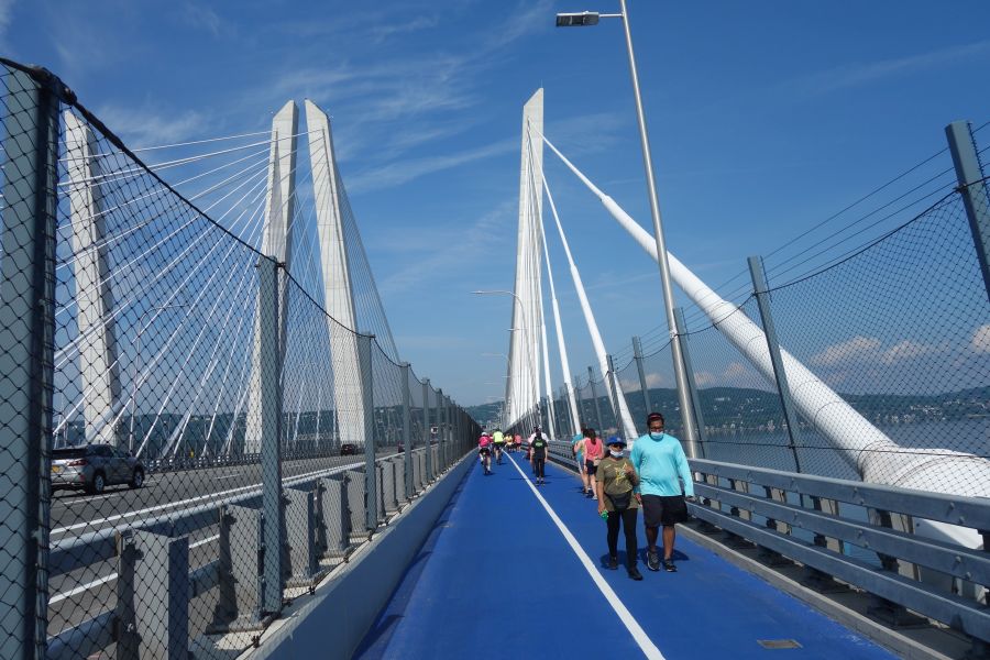
If you had the ability to design a brand-new, state of the art, bike path from scratch on a brand new bridge, you’d do something amazing, right?  Well that’s not what the Tappan Zee bike path is. It is more or less just a 12-foot car lane repurposed into a multi-use path with a white stripe going down the middle. Pedestrians on one side, bikes on the other.  Cross the line at your peril!  If you’ve been on a bike path on almost any other local bridge, this is more or less the same deal.  You’ve got cyclists of all abilities, all competing for the same space…right next to pedestrians.  It is absolutely essential to keep your wits about you.  But it’s a great path if you take your time and go slow. But at the same time, it’s also a really good idea to ride this path with a mirror so you can be ready for the packs of lycra-clad riders who come blowing through in a paceline, perilously close to young mothers riding with toddlers on the backs of their bikes.

Blocked view from Tappan Zee Bridge

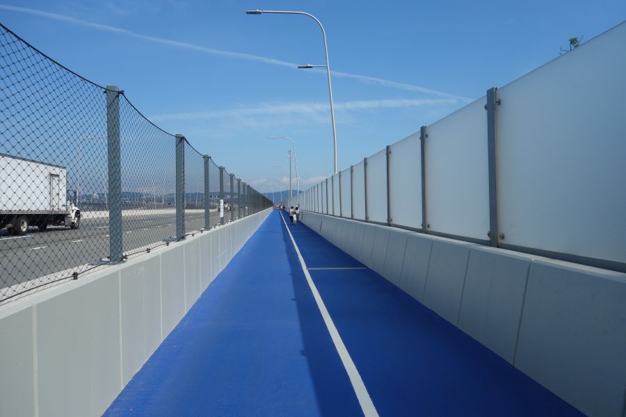
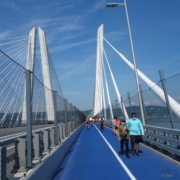
You told me there would be river views! Not here, as opaque panels shield your eyes from something you are not meant to see.

Besides, why not take your time and enjoy the view? It’s fantastic! But if you start out on the Westchester side, you’ll need to wait a bit.  For some reason, they put opaque panels blocking your view for the first part of the ride.  But then things open up, and there are 6 little rest areas you can stop at to enjoy the view.  These rest stops have whimsical names like “Fish and Ships”, but they are mostly just bland seating areas adorned with touchscreen monitors that will inform you about a different Hudson River topic. 

Tappan Zee Belvedere

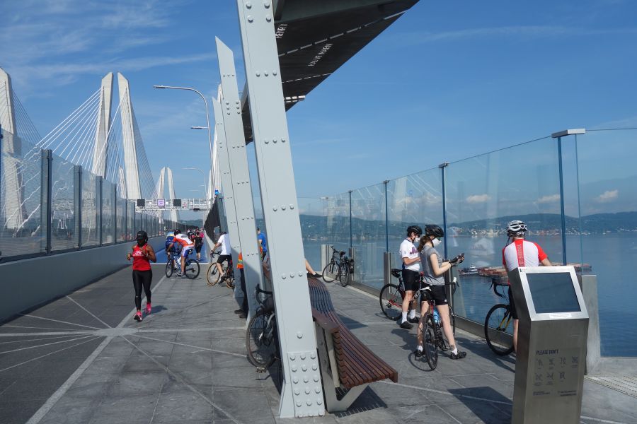
It’s time for some “fish and ships” at one of the seating areas along the bridge. Always a nice view. There’s also a touch screen for you to look at and touch.

The seating areas also offer some artistic flair for the bridge along with other public art installations that you can look at. The art is a great distraction from the sounds of 18-wheelers and buses roaring past you. Don’t forget, this bridge carries the NYS Thruway. But at least in the seating areas, the mesh suicide-proof fence between you and the traffic is replaced by glass paneling to attenuate the vehicular noise while you browse those touchscreen panels.

Public art Tappan Zee bridge

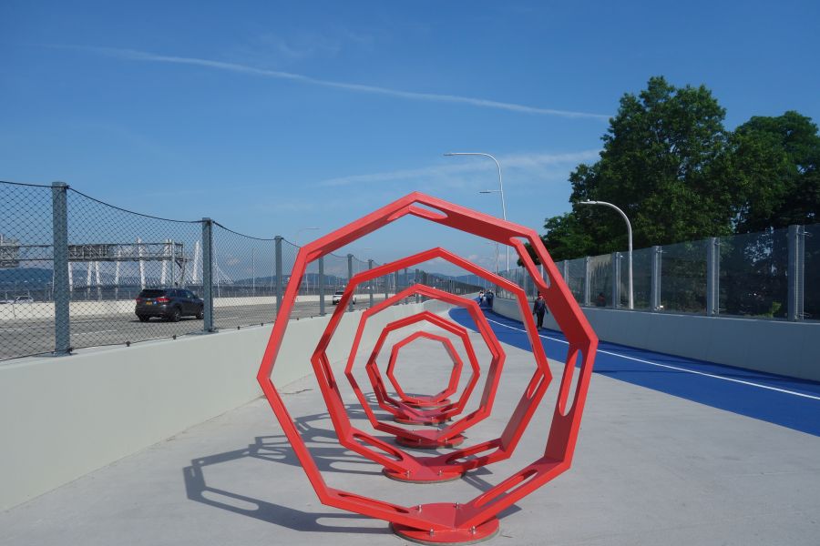
Get lost in public art installations along the bike path.

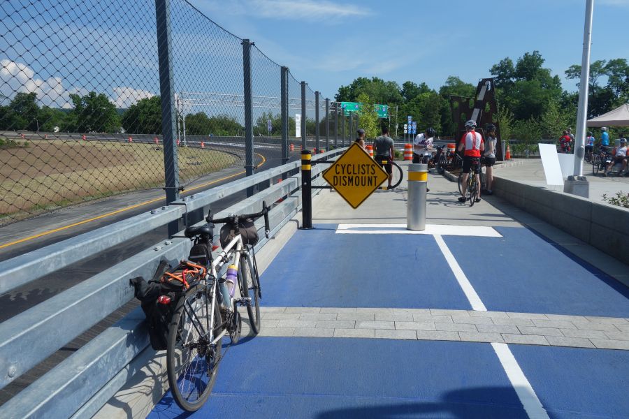
The Rockland side of the bridge approaches the shore at a much lower elevation than the Westchester side, and dispenses you amidst the tangle of Interchange 10.  The space here is tight and narrow-feeling thanks to the concrete sound-barrier walls. But at least you will be in the shade on a hot summer day.

Crowded Tappan Zee bike path

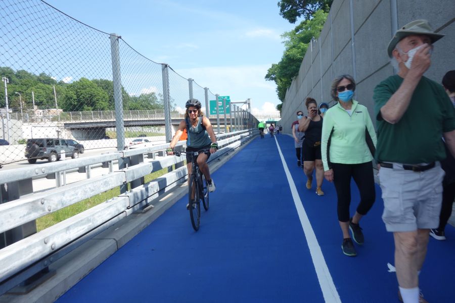
Approaching the Rockland side is “easy-squeezy” as the crowd is shunted between sound barrier walls and the suicide fence next to the traffic.

The bike path has great amenities on both landings of the bridge.  Each landing has a clean restroom near the parking lot, although there are few places to lock up your bike while you go inside. Each landing also has at least one food truck and a small area to consume the items you purchase. 

Tappan Zee food truck

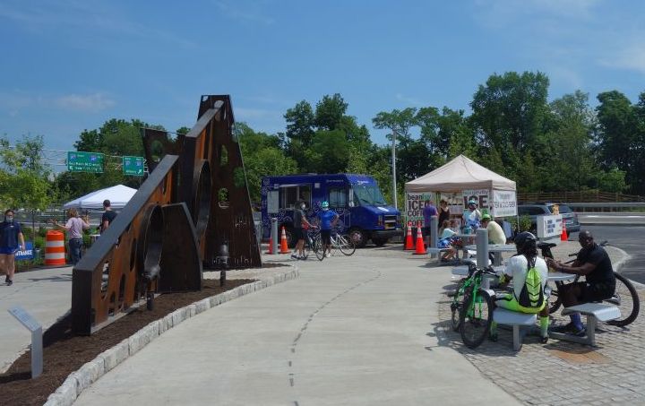
Grab a bite from a food truck and eat it on a metal picnic table with absolutely no shade. Public art provides a visual contrast to the pavement that surrounds you.

Getting there

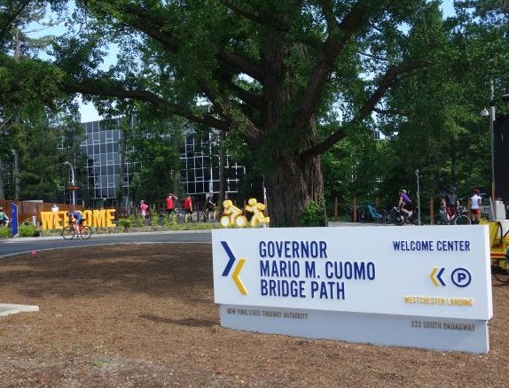
The Mario M. Cuomo Bridge is unique, compared to other bridges with bike paths, in that it has free parking for people to drive to the bridge and then ride or walk across it. But the bridge is also connected to other bike paths on both sides of the river, so you can also ride your bike to it.  On the Westchester side, the bridge is very close to the Old Croton Aqueduct Trail and the Westchester RiverWalk trail. It is easy to ride from these trails to the bridge by riding on the sidewalk of Route 9 between the trail and the bridge. You can also ride in the road if you want to.  

Cyclist dismount sign

This severe-looking design was clearly invented by the highway engineers. Welcome to the parking area.

On the Rockland side, the bridge connects directly to the Esposito Trail, which in turn will take you directly to downtown Nyack.  Nyack is probably the easiest community to visit when you are riding the bridge’s bike path. On the Westchester side, you can also visit Tarrytown, but you’ll have to ride down busy Route 9 to get there.  You could also go the other way and ride to Irvington, using the Old Croton Aqueduct or RiverWalk trails. 

Tappan Zee bike path signs

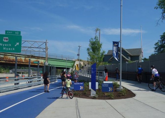
The bridge’s bike path connects to other trails. Clear signage ensures you will not get lost.

Another way to get to the bridge’s bike path is to use the Hudson Link bus.  These buses ply the I-287 corridor and offer stops near the bike path during certain times of the day.  The buses all have bike racks that hold up to 3 bikes.  So you can ride or walk the bridge one way, then take the bus back. 

Tappan Zee Bridge sign

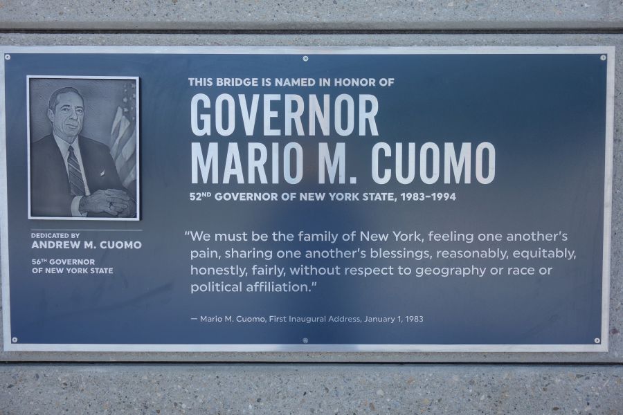
Hey! Don’t forget that the current governor named the bridge after his father, a previous governor. These signs ensure you don’t forget.

O&W Trail

Riding the O&W Rail Trail

The City of Kingston sits right next to the Catskill Mountains along the Hudson River. But it also sits at the end of two river valleys that run south to north. These two waterways: the Roundout Creek and the Wallkill River, have their confluence just south of Kingston.  From that point north, the Roundout Creek becomes a navigable waterway which leads to the small harbor that made Kingston a hub of industrial activity in the Mid-Hudson Valley.

The Roundout Valley has long been a transportation corridor.  First it was the Delaware and Hudson Canal that once transported coal between northeast Pennsylvania and the Hudson River.  Later the canal was replaced by the New York, Ontario and Western Railway (the O&W). And now that railroad alignment is another great bike path for you to explore. Riding this trail can be a great component of any of our Hudson Valley bike tours.  You could also combine it with our Catskill Scenic Trail tour and make a weekend out of it. 

The O&W is a quiet, peaceful ride. But it is still a work in progress in many ways.  There are a number of gaps in the trail, and some parts of the ride are kind of rough.  So you will definitely want to ride a hybrid bike or a mountain bike if you want to experience any of the rough parts.  There is a good map showing the different segments (and gaps) on the trail’s official website. The map also shows a number of parking areas as well. You can also take public transit to parts of the O&W trail by using Route EU of the Ulster County Area Transit bus system.  These buses are equipped with bike racks and can help you ride this route one-way, and take the bus back to your start point. 

Perhaps the roughest section of the trail is in Kingston where the O&W met the other lines that made Kingson a regional rail hub.  The trail begins in the parking lot of the Super 8 hotel where  the O&W once joined the tracks that are still in use by the Catskill Mountain Railroad.  Riding the trail in this area is basically riding on bumpy grass, and it can be tough at times. If you want to skip this area, you can start instead at the parking lot just off of Route 209 in Hurley.  From here south, the trail conditions begin to get better and it is a nice quiet ride through beautiful woods with great scenery. Although there are a couple of rough spots on the trail here and there. Once you reach High Falls, you will begin to ride along the Roundout Creek where you can see remnants of both the D&H Canal as well as the O&W Railroad. 

O&W Rail Trail conditions

Typical trail conditions on the O&W Rail Trail

There aren’t a lot of services or stores immediately next to the trail.  So you’ll want to pack some food to bring with you.  If you need to stop for supplies, your options are basically in Hurley, near the parking lot at the north end, and at Big E’s deli where the trail crosses Cottekill Road.  There are also some shops in High Falls if you get off the trail and cross the Roundout Creek.

This section of trail is more or less continuous until you reach the hamlet of Accord, where the trail peters out in a lumberyard.  From here you will need to continue along Lucas Turnpike and Route 209 if you want to keep going. These roads can be kind of busy and aren’t the greatest for riding, but more advanced riders should be OK.  

Shawangunk Ridge

A view of the Shawangunk Ridge from the O&W Trail

When you reach the center of Accord, you will need to go through town and cross the Roundout Creek.  There aren’t that many stores or services here, despite it being the center of town.  You will need find your way over to Rochester Town Park by taking County Road 27 to get to the next segment of trail.  But you may have to ride through the park for a while until you can figure out where the trail is.  Just look for the dump trucks and the trail should be behind them.  The trail is kind of rough here again, and it only goes for 4.3 miles until the next gap in the trail in Kerhonkson.  But you will ride along the Roundout Creek the entire time with great views of the Shawangunk Ridge. 

In Kerhonkson, if you want to keep riding, you’ll need to use Berme Road for 3.4 miles and it will take you to one last piece of trail – 1.2 miles in Ellenville. But it’s still a nice ride!  Kerhonskon also has a couple of restaurants, a brewery and a resort hotel making it a nice place to end your ride as well.

Ashokan Rail Trail

Riding the Ashokan Rail Trail

Ashokan Rail Trail

If you are looking for one of the most glorious 10- to 20-mile bike rides you can do in the Hudson Valley, look no further than the Ashokan Rail Trail.  This trail was recently opened in the fall of 2019 and is one of the region’s newest and best constructed trail facilities. While the trail is unpaved, the surface is a smooth crushed stone that is suitable for most bikes. The trail is also very wide, ranging from 10 to 12 feet in width, which is a lot wider than most bike paths in our region. The result is a beautiful trail experience that feels uncrowded. It’s also a great trail to do over a weekend, for example, by combining it with the Catskill Scenic Trail

Cyclist on Ashokan Rail Trail

Perhaps the best part of the Ashokan Rail Trail is its views of the Ashokan Reservoir. The Ashokan is one of the largest reservoirs in the NYC water supply system. However, access to the water is very limited, with only a few roads and pathways going up to the water’s edge. This trail has several stunning viewpoints of the reservoir, often with the Catskill Mountains in the background. There are many places to stop and enjoy the view. In between the lakeside viewpoints, the trail is mostly shaded by surrounding woods. This makes the Ashokan Rail Trail a nice place to ride in summer.  And of course in autumn, the trail is an explosion of fall color!

Ashokan Rail Trail surface and woods

The Ashokan Rail Trail is 10-12 feet wide and paved with crushed stone. Many sections are wooded, offering shade and lots of color in autumn.

Getting there

The Ashokan Rail Trail has a very good website that explains all aspects of the trail along with providing a map of the trail.  The map is very useful in guiding you towards the three parking lots along the trail, which runs east to west.  The Boiceville Bridge Trailhead parking is at the west end while the Woodstock Dike Trailhead is at the east end. Both trailheads have scenic viewpoints near them and all parking lots have portable toilets. A third parking lot is located in the center of the trail in Shokan. When you park, be aware that some of the spaces in the lot are reserved for anglers. Many of the creeks which feed the Ashokan Reservoir, including the Esopus Creek,  have excellent fishing. All parking lots have excellent signage directing you to them from NYS Route 28, which is the main corridor route through this part of the Catskills, connecting Kingston to Belleayre. 

Glenford Dike

Riding across the Glenford Dike offers great views of the Ashokan reservoir.

Despite its rural location, the Ashokan Rail Trail is also served by public transit, since the trail follows the general alignment of Route 28. Ulster County Area Transit Route Z provides this service, and the bus has bike racks for you to use. In addition, you can also take Pine Hill/Adirondack Trailways buses to this trail on any route that travels down Route 28. However, you would need to put your bicycle in some kind of box to do this. 

History

If you aren’t lured to the Ashokan Rail Trail simply for its magnificent views or great riding conditions, the fascinating history of this area is another reason to visit. The trail is built on top of the rail alignment for the Ulster and Delaware Railroad. This railroad, which initially began construction in the 1820’s with the intention of connecting the Delaware and Hudson Canal in Kingston with Oswego along Lake Ontario, was ultimately scaled back to travel between Kingston and Oneonta. As the only railroad that went entirely through the Catskills, the Ulster and Delaware played a crucial role in transporting agricultural products, timber, bluestone and coal.  It also offered robust passenger service for tourists vacationing in the Catskill Mountains. While the final train ran in 1976, there are still portions of the line that are used by scenic railroads, such as the Catskill Mountain Railroad which operates in Kingston, and the Delaware & Ulster Railroad which operates in Arkville. The Trolley Museum of New York also maintains and operates trains on the easternmost portion of the line along the Kingston waterfront.  In between where these railroads operate, there are sections of the railroad that have been converted into bike paths, such as the Ashokan Rail Trail, the Catskill Scenic Trail and the Kingston Greenline.  The Catskill Rail Explorers also offers unique pedal-powered rail cars on a section of track as well.  Along most of the line you can still see many railroad artifacts as well as some station buildings which have either been abandoned or repurposed, such as the Empire State Railway Museum

Boiceville Trestle

The Boiceville Trestle crosses the Esopus Creek and was reconstructed to accommodate the trail.

In addition to railroad history, the Ashokan Rail Trail also offers insight into the history and construction of the Ashokan Reservoir, which was constructed between 1907 and 1915, and displaced twelve communities containing 2,000 residents. While some of these communities were relocated to upland locations, you can still see the foundations of some of the buildings from the original communities in the reservoir when the water levels are low. 

The Ashokan Rail Trail has several interpretive panels along the length of the trail that tells the history of both the railroad, the reservoir and the surrounding area.  You can view the panels before you make your trip on the website.