Biking the Bronx River Pathway

The Bronx River Pathway is a unique and interesting trail that is big on scenery and fun to ride. It’s also really easy to get to, thanks to frequent train service that parallels the bike path. This makes one-way rides really easy to do. 

Bronx River Pathway in autumn

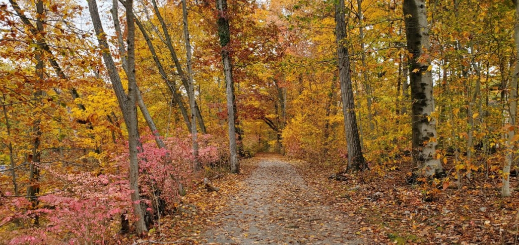
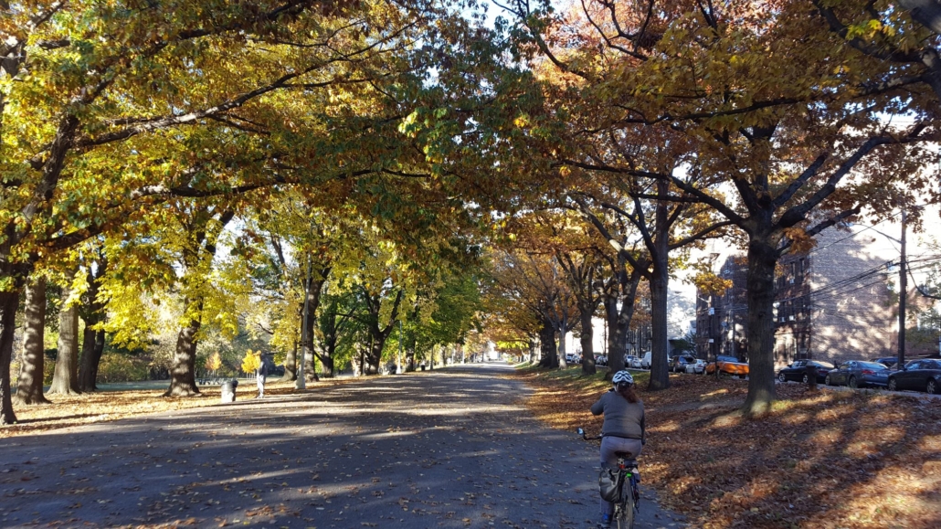
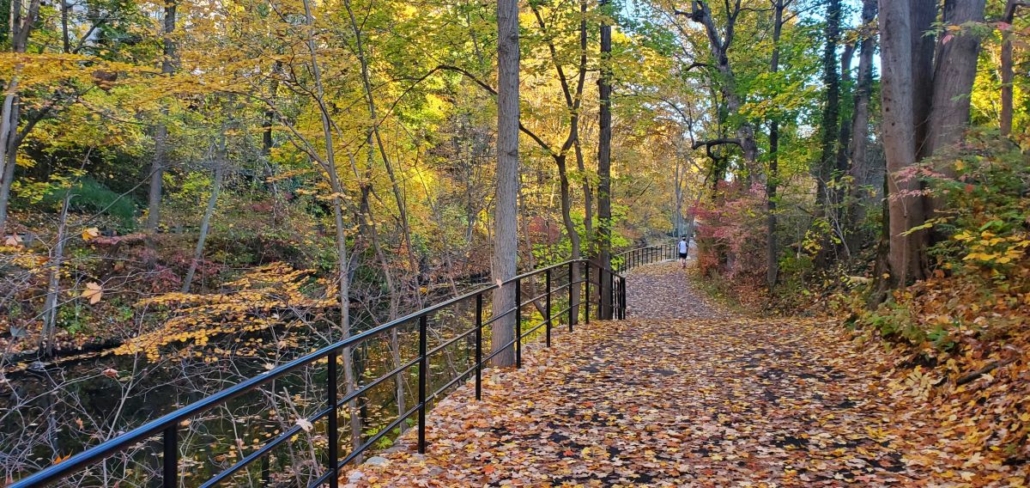
The Bronx River Pathway is beautiful! Especially in autumn.

A unique experience

What makes this path so special is that it was built as a part of the Bronx River Reservation. The Reservation began as a conservation effort in response to industrial development and pollution, but ultimately the Reservation became Westchester County’s first park. The park is associated with the Bronx River Parkway, the first vehicular parkway ever built in the United States.   

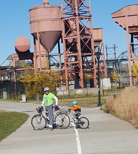
Riding the Bronx River Pathway on a bicycle is unlike any other bike path we’ve seen in the United States. It snakes through the tight Bronx River Valley, back and forth over the river on historically contextualized bridges. The route is entwined with the route of the Harlem Line, a railroad that has traveled this corridor since the mid 19th Century.  Every station along the line is a unique hub of activity, with restaurants and services. In between the path snakes through the woods, occasionally going up and down short (yet challenging) inclines where you are treated to view after view of a vibrant natural environment that changes with the seasons.  It’s never a bad time of year to ride your bike here.  It’s also a fantastic place to cross country ski whenever we get a snowfall greater than 6 inches.  

Bicycle on bridge over Bronx River

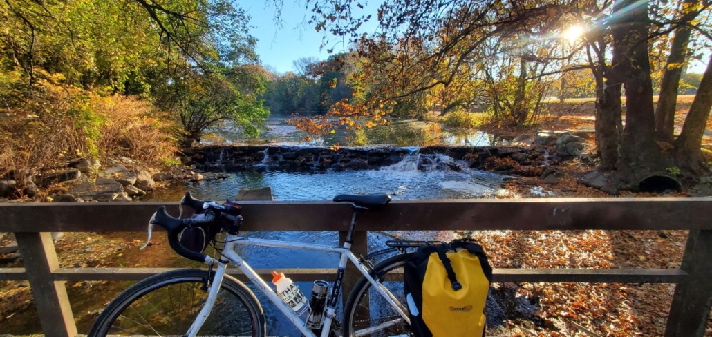
The Bronx River Pathway crosses the Bronx River many times. Often there are “waterfalls”. These are dams that once powered mills.

The main part of the Bronx River Pathway is an 11-mile stretch that runs between the Village of Bronxville and Kensico Dam Plaza in Valhalla. A smaller segment called the Oak Street Loop is located in Mount Vernon. Click here to see a map.  (The Bronx River Greenway also goes for several miles further south in the Bronx. The plan is to ultimately connect everything together.) 

Rent a bike and try this ride!

While there are few directional signs along the path, the bike path is (mostly) intuitive. The path also closely follows the Metro-North Harlem Line with direct access to seven train stations, making it perfect for getting to the trail and then back home again.  There is also free parking at many of these stations on weekends if you want to drive to the trail. Westchester County Parks has also produced a nice map of this trail showing access points and parking.   

Bronx River Pathway next to Bronx River

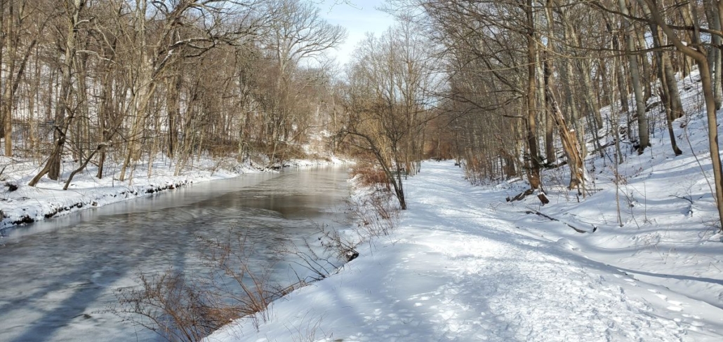
North of Scarsdale, the Bronx River Valley narrows and you are right along the river.

Biking the trail

Bronxville and Tuckahoe are villages at the southern end of the trail. The pathway goes around two  bucolic lakes (both with “waterfalls”) as you pass near each downtown area.  

North of Scarsdale Road in Yonkers, the bike path parallels the section of the Bronx River Parkway that is closed on Sundays in the spring and fall for “Bicycle Sundays”. This is a great experience, where you get to bike in the vehicular roadway. You can really take in how scenic this road is on a bike (since it’s usually “white knuckle driving” in a car)

Want to rent a bike and try out Bicycle Sunday?  Click here!

The path goes deep into Garth Woods when you get to Scarsdale.  This is a lovely section where you are surrounded by mature trees. A ramp from the trail goes directly to Scarsdale’s train station and commercial area. 

Between Hartsdale and White Plains the trail surface becomes unpaved and you go through another quiet natural area.  This area is excellent for cross country skiing in the winter.

Bronx River Pathway in winter

Whatever the season, there’s always reason to enjoy this awesome path. It’s one of the few places for cross country skiing that you can easily get to by train.

So many amenities, so close to a trail.

White Plains is the largest place you will pass through on the pathway.  You will begin to notice its skyline as you approach. The train station immediately abuts the pathway and provides express service to Manhattan. White Plains also has a robust downtown with hotels, restaurants and stores. The streets in White Plains are crazy, but there are also several streets with bike lanes that are safe if you know the way. (This is why you want GPS from us). It’s a great place to stay if you are from out of town and looking to explore the area by bike since its so close to such a great bike path!

Part of the experience in White Plains is biking past the Art Deco Westchester County Center. They have restrooms here, but you’ll have to cross the parkway using a pedestrian signal to get to them. You can also park here, but you have to pay a fee. 

Rent a bike and try this ride!

As you progress through North White Plains, the landscape opens up more as the valley widens. There is direct access to the North White Plains train station parking lot, which has free parking on weekends. 

Ultimately the trail ends at Kensico Dam Plaza, which is a County park located at the base of the imposing Kensico Dam. You can take a pathway (or stairs) to the top of the dam if you want to take a look around.  But it’s also nice to just ride around the plaza and see everyone enjoying the park!

Kensico Dam

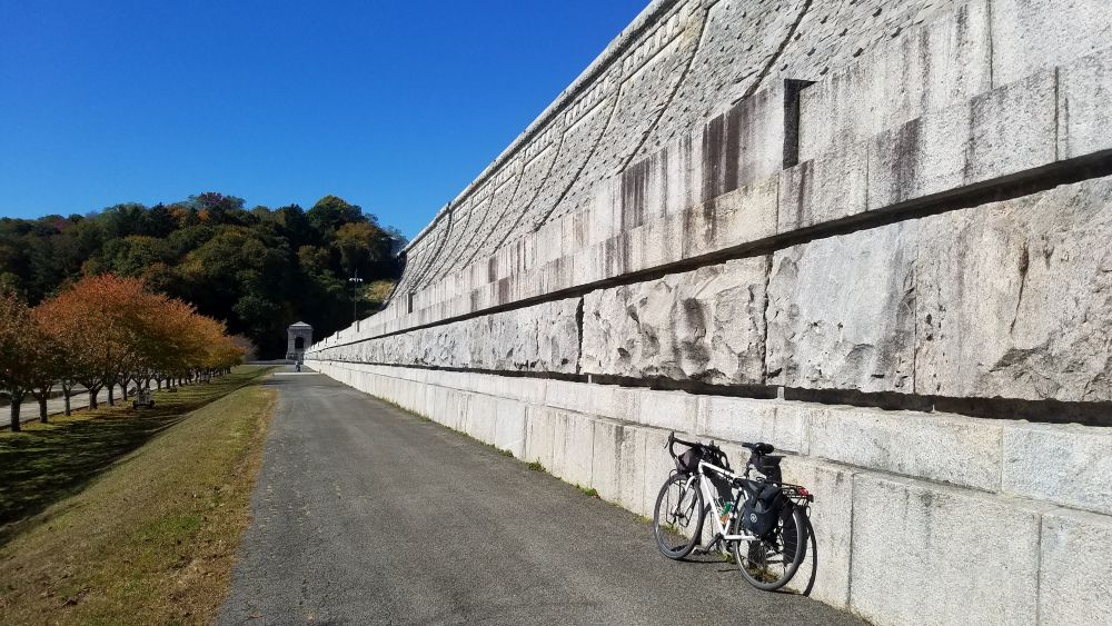
Kensico Dam Plaza is a bold visual finish to your ride.


Biking the Bronx River Greenway

The Bronx River Greenway is a fascinating and fun place to ride a bike. It follows the Bronx River for (almost) its entire length in the Bronx, taking you through areas that were once heavily industrial, but are now beautiful parks. It’s a great ride that you can do in a couple of hours that packs in a lot of scenery. 

Bicycle and Canoes on the Bronx River Greenway

The Bronx River Valley has been a corridor for transportation and industry throughout New York’s history. As the only fresh-water river in NYC it played an important role in industry, with many mills set up along its banks, the remnants of which can be seen in the many “waterfalls” you see along the river flowing over dams that date back centuries. When efforts were undertaken in the late 19th Century to begin to address pollution, the Bronx River Parkway was constructed, and lands along each side of the roadway were dedicated as parkland, including what is now the Bronx Zoo and the New York Botanical Gardens. This “green corridor”, set amidst the bustle of city life in the Bronx, is really what makes this bike path special.

Rent a bike and try this ride!

The route

Let’s take a look at the route from south to north.  For an overview map of the entire route in both the Bronx and Westchester, click here.  For this article we will focus on the Bronx sections. In Westchester County, the route becomes the Bronx River Pathway, and we have another blog article about that segment. 

A bicycle next to the mouth of the Bronx River

The Bronx River empties into the East River near Clason Point where NYC Ferry services are available.

Clason Point is at the south end. There is a dock here that gets regular NYC Ferry service which is a great way to arrive with your bike if you are coming from Brooklyn, Queens or Manhattan. Parking here is also relatively easy to find. From here you will ride through a series of parks with a little on-street riding in between each. Head directly out on a bike path which takes you through Soundview Park along the tidal flats of the mouth of the Bronx River. Then with a little knowledge of local streets from a map, you can get across the Bruckner Expressway to Concrete Plant Park where you can sometimes see canoes out on the river.

Rent a bike and try this ride!

The route signage north of here is very good, particularly as you head through Starlight Park, which is one the most recent additions to this trail. Much of this was built when NYSDOT decommissioned Sheridan Expressway (now Sheridan Boulevard) which was once the shortest interstate highway in the United States. The trail through here is fantastic, and it is where the Bronx River Alliance is headquartered.  This organization has done so much work to make this bike path a reality. 

Sunset over the Starlight Park bike path

Starlight Park has dramatic views, including a view of subway and Amtrak trains crossing the Bronx River.

North of here, the park land is interrupted as you go through the bustling West Farms neighborhood. This is a major transit hub for subways and buses, so it’s a good starting point if you want to take the subway to get to the ride. You can also try your luck with parking here since there is good highway access at this particular spot. Again a map is helpful getting you through the neighborhood streets.  Watch out for cars!

Rent a bike and try this ride!

The good news is that it’s only a half mile of on-street riding and then you are back on a nice bike path starting at 180th Street. At this point you are going to be on a path for a while as you go through Bronx Park, so relax and enjoy. If you are interested in an odd piece of New York history, take a very small detour to the East 180th Street subway station, which used to be a train terminal for the now-defunct New York, Boston and Westchester Railroad. Both the 2 and 5 trains stop here and the 5 continues on along the old NY,B &W route to Dyre Avenue.

Bronx River Pathway

The Bronx River Greenway in Shoelace Park is wide and straight.Once you are on this bike path, everything is straightforward and well marked almost until you reach the northern border of NYC. There are also plenty of restrooms and water fountains (usually found at playgrounds) along the way. The only challenging section is where you need to cross Pelham Parkway. This is a busy street that is difficult to cross.  So take your time and use the pedestrian signals.  Or check out the neighborhood and get a snack or lunch while you are there. 

North of Pelham Parkway, you will pass a convenient pedestrian-only entrance to the New York Botanical Gardens as you progress through Shoelace Park.  This is a long, unbroken stretch of trail that goes all the way to Woodlawn Heights, which is where NYC ends and Westchester County begins.  (We also offer bike rental out of our Woodlawn Heights location if you want to ride this trail!)  There are plans to connect the Bronx River Pathway in Westchester to the trail here in Woodlawn Heights.  But for now, you will need to rely on an on-road option.  You will want GPS from us to do this because the connections are not straightforward. 

Concrete Plant Park

Concrete Plant Park is an interesting segment of the Bronx River Greenway.